San Antonio del Cipres geodata
San Antonio del Cipres (Zacatecas) is a populated place; located in Mexico in America/Mexico_City (GMT-6) time zone. With population of 3,338 people, there are 2722 cities with bigger population in this country. Compared to other cities in Mexico, 87.9% of cities are located further ↓South; 84% of cities are located further →East and 81.1% of cities have lower elevation than San Antonio del Cipres. Note1
Current local time in San Antonio del Cipres:
03:40 AM, WednesdayDifference from your time zone: hours


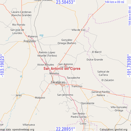
San Antonio del Cipres GPS coordinates[2]
22° 56' 18.852" North, 102° 29' 13.56" West
| Map corner | latitude | longitude |
|---|---|---|
| Upper-left | 23.58453°, | -103.19023° |
| Center: | 22.93857°, | -102.4871° |
| Lower-right: | 22.28951°, | -101.78398° |
| Map W x H: | 144×144 km | = 89.5×89.5mi |
| max Lat: | 32.7° ⇑12.1% North |
| San Antonio del Cipres: | 22.93857° |
| min Lat: | ⇓87.9% South 14.53588° |
| min Long | San Antonio del | max Long |
| -117.105° | -102.4871° | -86.73105° |
| W 16%⇐ | ⇒84% E |
Elevation
Elevation of San Antonio del Cipres is 2166 m = 7106 ft, and this is 912.3 m = 2993 ft above average elevation for this country.
| Max E: |
3497 m = 11473 ft | 18.9% |
| San Antonio del Cipres | 2166 m 7106 ft | |
| Avg. | 1253.7 m = 4113 ft | |
Min E: |
-1 m = -3 ft | 81.1% |
See also: Mexico elevation on elevation.city.
Geographical zone
San Antonio del Cipres is located in North Torrid zone (between Equator and Tropic of Cancer). Distance of this Northern Tropic circle is 55.4 km =34.4 mi to North.| Distance of | km | miles | from San Antonio del Cipres |
|---|---|---|---|
| North Pole | 7456.5 | 4633.3 | to North |
| Arctic Circle | 4850.6 | 3014 | to North |
| Tropic Cancer | 55.4 | 34.4 | to North |
| Equator | 2550.5 | 1584.8 | to South |


Nearby cities:
15 places around San Antonio del Cipres: (largest is in red/bold)
• Casa de Cerros
6.9 km =4.3 mi,  210°
210°
• El Lampotal
8.4 km =5.2 mi,  124°
124°
• Hacienda Nueva
17.7 km =11 mi,  224°
224°
• Laguna Seca
13.7 km =8.5 mi,  356°
356°
• Las Pilas
16.9 km =10.5 mi,  229°
229°
• Los Pozos
6.6 km =4.1 mi, 356°
• Morelos
15.2 km =9.4 mi,  236°
236°
• Pozos de Gamboa
8.6 km =5.3 mi,  277°
277°
• Pánuco
8.9 km =5.5 mi, 218°
• San José de la Era
11.8 km =7.3 mi,  145°
145°
• San Juan
13.6 km =8.5 mi,  52°
52°
• Santa Rita
7.6 km =4.7 mi,  112°
112°
• Sauceda de La Borda
12.1 km =7.5 mi,  187°
187°
• Tacoaleche
15.6 km =9.7 mi, 147°
• Vetagrande
13.6 km =8.5 mi, 211°
Sources, notices
• [Note1] Compared only with cities in Mexico existing in our database
• [Src1] Map data: © OpenStreetMap contributors (CC-BY-SA)
• [Src2] Other city data from geonames.org with taken over terms of usage.
• [Src3] Geographical zone / Annual Mean Temperature by Robert A. Rohde @ Wikipedia
