San Gabriel geodata
San Gabriel (Jalisco) is a seat of a second-order administrative division; located in Mexico in America/Mexico_City (GMT-6) time zone. With population of 4,606 people, there are 1997 cities with bigger population in this country. Compared to other cities in Mexico, 51.5% of cities are located further ↓South; 89.3% of cities are located further →East and 53.6% of cities have higher elevation than San Gabriel. Note1


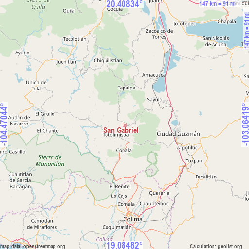
San Gabriel GPS coordinates[2]
19° 44' 52.62" North, 103° 46' 2.316" West
| Map corner | latitude | longitude |
|---|---|---|
| Upper-left | 20.40834°, | -104.47044° |
| Center: | 19.74795°, | -103.76731° |
| Lower-right: | 19.08482°, | -103.06419° |
| Map W x H: | 147.2×147.2 km | = 91.5×91.5mi |
| max Lat: | 32.7° ⇑48.5% North |
| San Gabriel: | 19.74795° |
| min Lat: | ⇓51.5% South 14.53588° |
| min Long | San Gabriel | max Long |
| -117.105° | -103.76731° | -86.73105° |
| W 10.7%⇐ | ⇒89.3% E |
Elevation
Elevation of San Gabriel is 1266 m = 4154 ft, and this is 12.3 m = 40 ft above average elevation for this country.
| Max E: |
3497 m = 11473 ft | 53.6% |
| San Gabriel | 1266 m 4154 ft | |
| Avg. | 1253.7 m = 4113 ft | |
Min E: |
-1 m = -3 ft | 46.4% |
See also: Mexico elevation on elevation.city.
Geographical zone
San Gabriel is located in North Torrid zone (between Equator and Tropic of Cancer). Distance of this Northern Tropic circle is 410.2 km =254.9 mi to North.| Distance of | km | miles | from San Gabriel |
|---|---|---|---|
| North Pole | 7811.3 | 4853.7 | to North |
| Arctic Circle | 5205.4 | 3234.5 | to North |
| Tropic Cancer | 410.2 | 254.9 | to North |
| Equator | 2195.8 | 1364.4 | to South |


Nearby cities:
15 places around San Gabriel: (largest is in red/bold)
• Alista
12.8 km =8 mi,  190°
190°
• Apango
6.9 km =4.3 mi,  58°
58°
• Atacco
20 km =12.4 mi,  7°
7°
• Copala
15.2 km =9.4 mi,  181°
181°
• El Jazmín
12.1 km =7.5 mi,  150°
150°
• Jiquilpan
3.6 km =2.2 mi,  340°
340°
• Las Primaveras [Invernadero]
9.1 km =5.7 mi,  229°
229°
• Los Colonos
21.7 km =13.5 mi,  358°
358°
• San Antonio
13.7 km =8.5 mi,  293°
293°
• San José del Rincón
9.7 km =6 mi,  282°
282°
• Sayula
23 km =14.3 mi,  49°
49°
• Tapalpa
22 km =13.7 mi,  2°
2°
• Tolimán
22.5 km =14 mi,  223°
223°
• Tonaya
21.8 km =13.5 mi, 281°
• Zapotitlán de Vadillo
22.6 km =14 mi, 191°
Sources, notices
• [Note1] Compared only with cities in Mexico existing in our database
• [Src1] Map data: © OpenStreetMap contributors (CC-BY-SA)
• [Src2] Other city data from geonames.org with taken over terms of usage.
• [Src3] Geographical zone / Annual Mean Temperature by Robert A. Rohde @ Wikipedia
