Sayula geodata
Sayula (Jalisco) is a seat of a second-order administrative division; located in Mexico in America/Mexico_City (GMT-6) time zone. With population of 26,789 people, there are 373 cities with bigger population in this country. Compared to other cities in Mexico, 54.7% of cities are located further ↓South; 88.7% of cities are located further →East and 51.2% of cities have higher elevation than Sayula. Note1


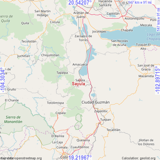
Sayula GPS coordinates[2]
19° 52' 56.1" North, 103° 36' 0.972" West
| Map corner | latitude | longitude |
|---|---|---|
| Upper-left | 20.54207°, | -104.3034° |
| Center: | 19.88225°, | -103.60027° |
| Lower-right: | 19.21967°, | -102.89715° |
| Map W x H: | 147×147 km | = 91.3×91.3mi |
| max Lat: | 32.7° ⇑45.3% North |
| Sayula: | 19.88225° |
| min Lat: | ⇓54.7% South 14.53588° |
| min Long | Sayula | max Long |
| -117.105° | -103.60027° | -86.73105° |
| W 11.3%⇐ | ⇒88.7% E |
Elevation
Elevation of Sayula is 1373 m = 4505 ft, and this is 119.3 m = 391 ft above average elevation for this country.
| Max E: |
3497 m = 11473 ft | 51.2% |
| Sayula | 1373 m 4505 ft | |
| Avg. | 1253.7 m = 4113 ft | |
Min E: |
-1 m = -3 ft | 48.8% |
See also: Mexico elevation on elevation.city.
Geographical zone
Sayula is located in North Torrid zone (between Equator and Tropic of Cancer). Distance of this Northern Tropic circle is 395.2 km =245.6 mi to North.| Distance of | km | miles | from Sayula |
|---|---|---|---|
| North Pole | 7796.4 | 4844.5 | to North |
| Arctic Circle | 5190.5 | 3225.2 | to North |
| Tropic Cancer | 395.2 | 245.6 | to North |
| Equator | 2210.7 | 1373.7 | to South |


Nearby cities:
15 places around Sayula: (largest is in red/bold)
• Amacueca
14.3 km =8.9 mi,  0°
0°
• Apango
16.2 km =10.1 mi,  225°
225°
• Atacco
15.7 km =9.8 mi,  288°
288°
• Atoyac
16.7 km =10.4 mi,  31°
31°
• Cuyacapan
12.4 km =7.7 mi,  40°
40°
• El Rodeo
17.8 km =11.1 mi,  104°
104°
• Gómez Farías
16.3 km =10.1 mi,  127°
127°
• Los Espinos
18.5 km =11.5 mi,  308°
308°
• San Andrés Ixtlán
15.4 km =9.6 mi,  116°
116°
• San Antonio
14.7 km =9.1 mi, 309°
• San Sebastián del Sur
16.5 km =10.3 mi, 126°
• Tapalpa
18.1 km =11.2 mi, 292°
• Tepec
12.7 km =7.9 mi,  340°
340°
• Unión de Guadalupe
15.9 km =9.9 mi,  78°
78°
• Usmajac
6.3 km =3.9 mi, 97°
Sources, notices
• [Note1] Compared only with cities in Mexico existing in our database
• [Src1] Map data: © OpenStreetMap contributors (CC-BY-SA)
• [Src2] Other city data from geonames.org with taken over terms of usage.
• [Src3] Geographical zone / Annual Mean Temperature by Robert A. Rohde @ Wikipedia
