Uriangato geodata
Uriangato (Guanajuato) is a seat of a second-order administrative division; located in Mexico in America/Mexico_City (GMT-6) time zone. With population of 51,382 people, there are 220 cities with bigger population in this country. Compared to other cities in Mexico, 60% of cities are located further ↓South; 74.9% of cities are located further →East and 64.4% of cities have lower elevation than Uriangato. Note1


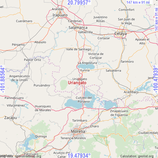
Uriangato GPS coordinates[2]
20° 8' 27.06" North, 101° 10' 57.036" West
| Map corner | latitude | longitude |
|---|---|---|
| Upper-left | 20.79957°, | -101.88564° |
| Center: | 20.14085°, | -101.18251° |
| Lower-right: | 19.47934°, | -100.47939° |
| Map W x H: | 146.8×146.8 km | = 91.2×91.2mi |
| max Lat: | 32.7° ⇑40% North |
| Uriangato: | 20.14085° |
| min Lat: | ⇓60% South 14.53588° |
| min Long | Uriangato | max Long |
| -117.105° | -101.18251° | -86.73105° |
| W 25.1%⇐ | ⇒74.9% E |
Elevation
Elevation of Uriangato is 1810 m = 5938 ft, and this is 556.3 m = 1825 ft above average elevation for this country.
| Max E: |
3497 m = 11473 ft | 35.6% |
| Uriangato | 1810 m 5938 ft | |
| Avg. | 1253.7 m = 4113 ft | |
Min E: |
-1 m = -3 ft | 64.4% |
See also: Uriangato elevation on elevation.city.
Geographical zone
Uriangato is located in North Torrid zone (between Equator and Tropic of Cancer). Distance of this Northern Tropic circle is 366.5 km =227.7 mi to North.| Distance of | km | miles | from Uriangato |
|---|---|---|---|
| North Pole | 7767.6 | 4826.6 | to North |
| Arctic Circle | 5161.7 | 3207.3 | to North |
| Tropic Cancer | 366.5 | 227.7 | to North |
| Equator | 2239.5 | 1391.6 | to South |


Nearby cities:
15 places around Uriangato: (largest is in red/bold)
• Colonia Juárez
3.6 km =2.2 mi,  83°
83°
• Cuaracurío
9.6 km =6 mi,  157°
157°
• El Charco
5.6 km =3.5 mi, 84°
• El Derramadero
8.7 km =5.4 mi,  139°
139°
• Las Misiones
2.6 km =1.6 mi,  30°
30°
• Monte de los Juárez
8.5 km =5.3 mi,  303°
303°
• Moroleón
2 km =1.2 mi,  210°
210°
• Ochomitas
9.5 km =5.9 mi,  345°
345°
• Parangarico
6 km =3.7 mi,  17°
17°
• Porullo
9.5 km =5.9 mi,  71°
71°
• Rinconadas del Bosque
6.4 km =4 mi,  194°
194°
• San Andrés Enguaro
8.2 km =5.1 mi,  316°
316°
• San José Cuaracurio
4.9 km =3 mi,  148°
148°
• San Miguel el Alto (San Miguelito)
7.5 km =4.7 mi,  2°
2°
• Yuriria
9.4 km =5.8 mi, 34°
Sources, notices
• [Note1] Compared only with cities in Mexico existing in our database
• [Src1] Map data: © OpenStreetMap contributors (CC-BY-SA)
• [Src2] Other city data from geonames.org with taken over terms of usage.
• [Src3] Geographical zone / Annual Mean Temperature by Robert A. Rohde @ Wikipedia
