Sinahuiza geodata
Sinahuiza (Sonora) is a populated place; located in Mexico in America/Hermosillo (GMT-7) time zone. With population of 1,008 people, there are 8648 cities with bigger population in this country. Compared to other cities in Mexico, 96.2% of cities are located further ↓South; 97.5% of cities are located further →East and 85.3% of cities have higher elevation than Sinahuiza. Note1


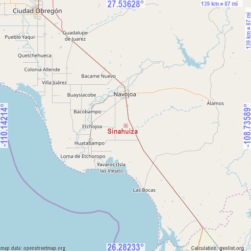
Sinahuiza GPS coordinates[2]
26° 54' 39.78" North, 109° 26' 20.436" West
| Map corner | latitude | longitude |
|---|---|---|
| Upper-left | 27.53628°, | -110.14214° |
| Center: | 26.91105°, | -109.43901° |
| Lower-right: | 26.28233°, | -108.73589° |
| Map W x H: | 139.4×139.4 km | = 86.6×86.6mi |
| max Lat: | 32.7° ⇑3.8% North |
| Sinahuiza: | 26.91105° |
| min Lat: | ⇓96.2% South 14.53588° |
| min Long | Sinahuiza | max Long |
| -117.105° | -109.43901° | -86.73105° |
| W 2.5%⇐ | ⇒97.5% E |
Elevation
Elevation of Sinahuiza is 42 m = 138 ft, and this is 1211.7 m = 3975 ft below average elevation for this country.
| Max E: |
3497 m = 11473 ft | 85.3% |
| Avg. | 1253.7 m = 4113 ft | |
| Sinahuiza | 42 m = 138 ft | |
Min E: |
-1 m = -3 ft | 14.7% |
See also: Mexico elevation on elevation.city.
Geographical zone
Sinahuiza is located in North temperate zone (between Tropic of Cancer and the Arctic Circle). Distance of this Northern Tropic circle is 386.3 km =240 mi to South.| Distance of | km | miles | from Sinahuiza |
|---|---|---|---|
| North Pole | 7014.8 | 4358.8 | to North |
| Arctic Circle | 4408.9 | 2739.6 | to North |
| Tropic Cancer | 386.3 | 240 | to South |
| Equator | 2992.2 | 1859.3 | to South |


Nearby cities:
15 places around Sinahuiza: (largest is in red/bold)
• Bacabachi
4.9 km =3 mi,  111°
111°
• Buayums
5.3 km =3.3 mi,  174°
174°
• Chinotahueca
15.6 km =9.7 mi,  324°
324°
• Chirajobampo
3.8 km =2.4 mi, 113°
• Chucarit
19.7 km =12.2 mi,  312°
312°
• El Recodo
20.5 km =12.7 mi,  334°
334°
• El Saneal
5 km =3.1 mi,  89°
89°
• Etchojoa
18.5 km =11.5 mi,  269°
269°
• Guayparín
21.5 km =13.4 mi,  286°
286°
• La Unión
19.6 km =12.2 mi,  238°
238°
• Las Playitas
19.2 km =11.9 mi,  295°
295°
• Navojoa
17.7 km =11 mi,  358°
358°
• Navolato
18.8 km =11.7 mi, 316°
• San Pedro Viejo
21.7 km =13.5 mi, 303°
• Sebampo
13.6 km =8.5 mi,  255°
255°
Sources, notices
• [Note1] Compared only with cities in Mexico existing in our database
• [Src1] Map data: © OpenStreetMap contributors (CC-BY-SA)
• [Src2] Other city data from geonames.org with taken over terms of usage.
• [Src3] Geographical zone / Annual Mean Temperature by Robert A. Rohde @ Wikipedia
