Zacapuato geodata
Zacapuato (Guerrero) is a populated place; located in Mexico in America/Mexico_City (GMT-6) time zone. With population of 1,860 people, there are 4671 cities with bigger population in this country. Compared to other cities in Mexico, 70.6% of cities are located further ↑North; 70.4% of cities are located further →East and 71.1% of cities have higher elevation than Zacapuato. Note1


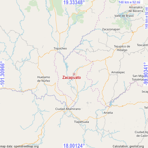
Zacapuato GPS coordinates[2]
18° 40' 7.212" North, 100° 36' 23.508" West
| Map corner | latitude | longitude |
|---|---|---|
| Upper-left | 19.33348°, | -101.30966° |
| Center: | 18.66867°, | -100.60653° |
| Lower-right: | 18.00124°, | -99.90341° |
| Map W x H: | 148.1×148.1 km | = 92×92mi |
| max Lat: | 32.7° ⇑70.6% North |
| Zacapuato: | 18.66867° |
| min Lat: | ⇓29.4% South 14.53588° |
| min Long | Zacapuato | max Long |
| -117.105° | -100.60653° | -86.73105° |
| W 29.6%⇐ | ⇒70.4% E |
Elevation
Elevation of Zacapuato is 364 m = 1194 ft, and this is 889.7 m = 2919 ft below average elevation for this country.
| Max E: |
3497 m = 11473 ft | 71.1% |
| Avg. | 1253.7 m = 4113 ft | |
| Zacapuato | 364 m = 1194 ft | |
Min E: |
-1 m = -3 ft | 28.9% |
See also: Mexico elevation on elevation.city.
Geographical zone
Zacapuato is located in North Torrid zone (between Equator and Tropic of Cancer). Distance of this Northern Tropic circle is 530.2 km =329.5 mi to North.| Distance of | km | miles | from Zacapuato |
|---|---|---|---|
| North Pole | 7931.3 | 4928.3 | to North |
| Arctic Circle | 5325.4 | 3309 | to North |
| Tropic Cancer | 530.2 | 329.5 | to North |
| Equator | 2075.8 | 1289.8 | to South |


Nearby cities:
15 places around Zacapuato: (largest is in red/bold)
• Angao
19 km =11.8 mi,  273°
273°
• Arroyo Grande
9 km =5.6 mi,  277°
277°
• Balderrama
9.4 km =5.8 mi,  43°
43°
• Bejucos
22.4 km =13.9 mi,  57°
57°
• Cañadas de Nanchititla
27.2 km =16.9 mi, 37°
• Cuadrilla Nueva
26.5 km =16.5 mi,  171°
171°
• Cutzamala de Pinzón
22.5 km =14 mi, 173°
• El Salitre (Sirapitiro)
8.7 km =5.4 mi,  162°
162°
• Mayaltepec
26.7 km =16.6 mi,  111°
111°
• Nuevo Galeana
13.8 km =8.6 mi,  189°
189°
• Otlatepec (Agua del Padre)
21.1 km =13.1 mi,  147°
147°
• Palmar Chico
25.3 km =15.7 mi,  83°
83°
• Palmar Grande
22.9 km =14.2 mi, 114°
• San Lucas
20.8 km =12.9 mi,  245°
245°
• Tamácuaro
19.9 km =12.4 mi, 193°
Sources, notices
• [Note1] Compared only with cities in Mexico existing in our database
• [Src1] Map data: © OpenStreetMap contributors (CC-BY-SA)
• [Src2] Other city data from geonames.org with taken over terms of usage.
• [Src3] Geographical zone / Annual Mean Temperature by Robert A. Rohde @ Wikipedia
