San Juanito geodata
San Juanito (Chihuahua) is a populated place; located in Mexico in America/Chihuahua (GMT-6) time zone. With population of 10,535 people, there are 902 cities with bigger population in this country. Compared to other cities in Mexico, 97.3% of cities are located further ↓South; 95.1% of cities are located further →East and 89.9% of cities have lower elevation than San Juanito. Note1


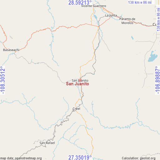
San Juanito GPS coordinates[2]
27° 58' 22.62" North, 107° 36' 7.164" West
| Map corner | latitude | longitude |
|---|---|---|
| Upper-left | 28.59213°, | -108.30512° |
| Center: | 27.97295°, | -107.60199° |
| Lower-right: | 27.35019°, | -106.89887° |
| Map W x H: | 138.1×138.1 km | = 85.8×85.8mi |
| max Lat: | 32.7° ⇑2.7% North |
| San Juanito: | 27.97295° |
| min Lat: | ⇓97.3% South 14.53588° |
| min Long | San Juanito | max Long |
| -117.105° | -107.60199° | -86.73105° |
| W 4.9%⇐ | ⇒95.1% E |
Elevation
Elevation of San Juanito is 2405 m = 7890 ft, and this is 1151.3 m = 3777 ft above average elevation for this country.
| Max E: |
3497 m = 11473 ft | 10.1% |
| San Juanito | 2405 m 7890 ft | |
| Avg. | 1253.7 m = 4113 ft | |
Min E: |
-1 m = -3 ft | 89.9% |
See also: Mexico elevation on elevation.city.
Geographical zone
San Juanito is located in North temperate zone (between Tropic of Cancer and the Arctic Circle). Distance of this Northern Tropic circle is 504.4 km =313.4 mi to South.| Distance of | km | miles | from San Juanito |
|---|---|---|---|
| North Pole | 6896.8 | 4285.5 | to North |
| Arctic Circle | 4290.9 | 2666.2 | to North |
| Tropic Cancer | 504.4 | 313.4 | to South |
| Equator | 3110.3 | 1932.7 | to South |


Nearby cities:
15 places around San Juanito: (largest is in red/bold)
• Adolfo López Mateos
62.4 km =38.8 mi,  28°
28°
• Bocoyna
14.7 km =9.1 mi,  175°
175°
• Cajurichic
54.3 km =33.7 mi,  285°
285°
• Carichí
53.9 km =33.5 mi,  96°
96°
• Creel
24.9 km =15.5 mi,  187°
187°
• La Junta
62.4 km =38.8 mi, 25°
• Maguarichi
40.5 km =25.2 mi,  251°
251°
• Pachera
39.9 km =24.8 mi, 29°
• Ranchos de Santiago
58.8 km =36.5 mi,  44°
44°
• San Rafael
60 km =37.3 mi,  208°
208°
• Sisoguichi
23.6 km =14.7 mi,  153°
153°
• Tacuba
43.9 km =27.3 mi,  16°
16°
• Tomochic
48.5 km =30.1 mi,  330°
330°
• Uruachi
61.4 km =38.2 mi,  258°
258°
• Álamos de Cerro Prieto
54.4 km =33.8 mi,  63°
63°
Sources, notices
• [Note1] Compared only with cities in Mexico existing in our database
• [Src1] Map data: © OpenStreetMap contributors (CC-BY-SA)
• [Src2] Other city data from geonames.org with taken over terms of usage.
• [Src3] Geographical zone / Annual Mean Temperature by Robert A. Rohde @ Wikipedia
