Cajurichic geodata
Cajurichic (Chihuahua) is a populated place; located in Mexico in America/Chihuahua (GMT-6) time zone. With population of 781 people, there are 11181 cities with bigger population in this country. Compared to other cities in Mexico, 97.4% of cities are located further ↓South; 95.7% of cities are located further →East and 81.5% of cities have lower elevation than Cajurichic. Note1


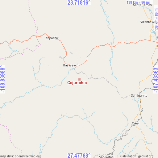
Cajurichic GPS coordinates[2]
28° 5' 58.956" North, 108° 8' 12.3" West
| Map corner | latitude | longitude |
|---|---|---|
| Upper-left | 28.71816°, | -108.83988° |
| Center: | 28.09971°, | -108.13675° |
| Lower-right: | 27.47768°, | -107.43363° |
| Map W x H: | 137.9×137.9 km | = 85.7×85.7mi |
| max Lat: | 32.7° ⇑2.6% North |
| Cajurichic: | 28.09971° |
| min Lat: | ⇓97.4% South 14.53588° |
| min Long | Cajurichic | max Long |
| -117.105° | -108.13675° | -86.73105° |
| W 4.3%⇐ | ⇒95.7% E |
Elevation
Elevation of Cajurichic is 2175 m = 7136 ft, and this is 921.3 m = 3023 ft above average elevation for this country.
| Max E: |
3497 m = 11473 ft | 18.5% |
| Cajurichic | 2175 m 7136 ft | |
| Avg. | 1253.7 m = 4113 ft | |
Min E: |
-1 m = -3 ft | 81.5% |
See also: Mexico elevation on elevation.city.
Geographical zone
Cajurichic is located in North temperate zone (between Tropic of Cancer and the Arctic Circle). Distance of this Northern Tropic circle is 518.5 km =322.2 mi to South.| Distance of | km | miles | from Cajurichic |
|---|---|---|---|
| North Pole | 6882.7 | 4276.7 | to North |
| Arctic Circle | 4276.8 | 2657.5 | to North |
| Tropic Cancer | 518.5 | 322.2 | to South |
| Equator | 3124.4 | 1941.4 | to South |


Nearby cities:
15 places around Cajurichic: (largest is in red/bold)
• Basaseachic
14 km =8.7 mi,  327°
327°
• Bocoyna
61 km =37.9 mi,  118°
118°
• Creel
62.7 km =39 mi,  128°
128°
• Maguarichi
30.2 km =18.8 mi,  152°
152°
• Maycoba
60.6 km =37.7 mi,  302°
302°
• Moris
38.3 km =23.8 mi,  278°
278°
• Ocampo
24.9 km =15.5 mi,  294°
294°
• Pachera
75.1 km =46.7 mi,  74°
74°
• San Juanito
54.3 km =33.7 mi,  105°
105°
• San Rafael
71.2 km =44.2 mi,  160°
160°
• Sisoguichi
72.2 km =44.9 mi, 119°
• Tacuba
70.8 km =44 mi, 66°
• Tomochic
40.1 km =24.9 mi,  45°
45°
• Uruachi
27 km =16.8 mi,  196°
196°
• Yepachic
42.8 km =26.6 mi, 326°
Sources, notices
• [Note1] Compared only with cities in Mexico existing in our database
• [Src1] Map data: © OpenStreetMap contributors (CC-BY-SA)
• [Src2] Other city data from geonames.org with taken over terms of usage.
• [Src3] Geographical zone / Annual Mean Temperature by Robert A. Rohde @ Wikipedia
