Bocoyna geodata
Bocoyna (Chihuahua) is a seat of a second-order administrative division; located in Mexico in America/Chihuahua (GMT-6) time zone. With population of 796 people, there are 10956 cities with bigger population in this country. Compared to other cities in Mexico, 97.1% of cities are located further ↓South; 95.1% of cities are located further →East and 83.5% of cities have lower elevation than Bocoyna. Note1


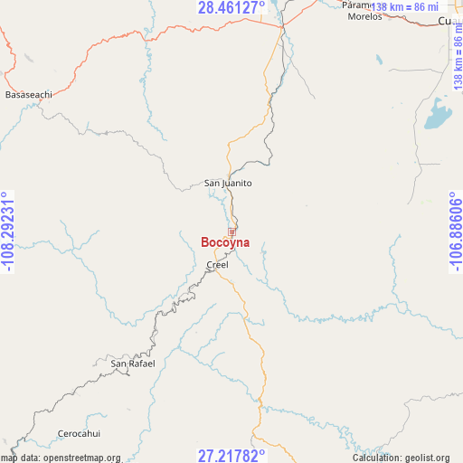
Bocoyna GPS coordinates[2]
27° 50' 28.788" North, 107° 35' 21.048" West
| Map corner | latitude | longitude |
|---|---|---|
| Upper-left | 28.46127°, | -108.29231° |
| Center: | 27.84133°, | -107.58918° |
| Lower-right: | 27.21782°, | -106.88606° |
| Map W x H: | 138.3×138.3 km | = 85.9×85.9mi |
| max Lat: | 32.7° ⇑2.9% North |
| Bocoyna: | 27.84133° |
| min Lat: | ⇓97.1% South 14.53588° |
| min Long | Bocoyna | max Long |
| -117.105° | -107.58918° | -86.73105° |
| W 4.9%⇐ | ⇒95.1% E |
Elevation
Elevation of Bocoyna is 2231 m = 7320 ft, and this is 977.3 m = 3206 ft above average elevation for this country.
| Max E: |
3497 m = 11473 ft | 16.5% |
| Bocoyna | 2231 m 7320 ft | |
| Avg. | 1253.7 m = 4113 ft | |
Min E: |
-1 m = -3 ft | 83.5% |
See also: Mexico elevation on elevation.city.
Geographical zone
Bocoyna is located in North temperate zone (between Tropic of Cancer and the Arctic Circle). Distance of this Northern Tropic circle is 489.7 km =304.3 mi to South.| Distance of | km | miles | from Bocoyna |
|---|---|---|---|
| North Pole | 6911.4 | 4294.5 | to North |
| Arctic Circle | 4305.5 | 2675.3 | to North |
| Tropic Cancer | 489.7 | 304.3 | to South |
| Equator | 3095.7 | 1923.6 | to South |


Nearby cities:
15 places around Bocoyna: (largest is in red/bold)
• Bahuichivo
67.3 km =41.8 mi,  224°
224°
• Cajurichic
61 km =37.9 mi,  298°
298°
• Carichí
53 km =32.9 mi,  80°
80°
• Creel
11.1 km =6.9 mi,  204°
204°
• Maguarichi
39.8 km =24.7 mi,  272°
272°
• Pachera
52.7 km =32.7 mi,  20°
20°
• Ranchos de Santiago
69.3 km =43.1 mi,  35°
35°
• Samachique
60.2 km =37.4 mi,  175°
175°
• San Juanito
14.7 km =9.1 mi,  355°
355°
• San Rafael
48.4 km =30.1 mi, 217°
• Sisoguichi
11.3 km =7 mi,  125°
125°
• Tacuba
57.8 km =35.9 mi,  11°
11°
• Tomochic
62.2 km =38.6 mi,  336°
336°
• Uruachi
61.6 km =38.3 mi, 272°
• Álamos de Cerro Prieto
61.2 km =38 mi,  50°
50°
Sources, notices
• [Note1] Compared only with cities in Mexico existing in our database
• [Src1] Map data: © OpenStreetMap contributors (CC-BY-SA)
• [Src2] Other city data from geonames.org with taken over terms of usage.
• [Src3] Geographical zone / Annual Mean Temperature by Robert A. Rohde @ Wikipedia
