Creel geodata
Creel (Chihuahua) is a populated place; located in Mexico in America/Chihuahua (GMT-6) time zone. With population of 5,026 people, there are 1836 cities with bigger population in this country. Compared to other cities in Mexico, 97.1% of cities are located further ↓South; 95.2% of cities are located further →East and 88.1% of cities have lower elevation than Creel. Note1


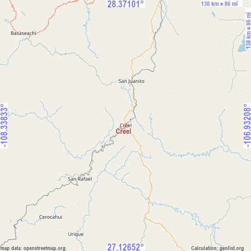
Creel GPS coordinates[2]
27° 45' 1.944" North, 107° 38' 6.72" West
| Map corner | latitude | longitude |
|---|---|---|
| Upper-left | 28.37101°, | -108.33833° |
| Center: | 27.75054°, | -107.6352° |
| Lower-right: | 27.12652°, | -106.93208° |
| Map W x H: | 138.4×138.4 km | = 86×86mi |
| max Lat: | 32.7° ⇑2.9% North |
| Creel: | 27.75054° |
| min Lat: | ⇓97.1% South 14.53588° |
| min Long | Creel | max Long |
| -117.105° | -107.6352° | -86.73105° |
| W 4.8%⇐ | ⇒95.2% E |
Elevation
Elevation of Creel is 2346 m = 7697 ft, and this is 1092.3 m = 3584 ft above average elevation for this country.
| Max E: |
3497 m = 11473 ft | 11.9% |
| Creel | 2346 m 7697 ft | |
| Avg. | 1253.7 m = 4113 ft | |
Min E: |
-1 m = -3 ft | 88.1% |
See also: Mexico elevation on elevation.city.
Geographical zone
Creel is located in North temperate zone (between Tropic of Cancer and the Arctic Circle). Distance of this Northern Tropic circle is 479.7 km =298.1 mi to South.| Distance of | km | miles | from Creel |
|---|---|---|---|
| North Pole | 6921.5 | 4300.8 | to North |
| Arctic Circle | 4315.6 | 2681.6 | to North |
| Tropic Cancer | 479.7 | 298.1 | to South |
| Equator | 3085.6 | 1917.3 | to South |


Nearby cities:
15 places around Creel: (largest is in red/bold)
• Bahuichivo
57 km =35.4 mi,  228°
228°
• Bocoyna
11.1 km =6.9 mi,  24°
24°
• Cajurichic
62.7 km =39 mi,  308°
308°
• Carichí
59.8 km =37.2 mi,  72°
72°
• Cerocahui
65.1 km =40.5 mi,  219°
219°
• Guapalaina
68.6 km =42.6 mi,  201°
201°
• Maguarichi
37.3 km =23.2 mi,  288°
288°
• Pachera
63.7 km =39.6 mi, 21°
• Samachique
50.8 km =31.6 mi,  169°
169°
• San Juanito
24.9 km =15.5 mi,  7°
7°
• San Rafael
37.8 km =23.5 mi, 221°
• Sisoguichi
14.2 km =8.8 mi,  75°
75°
• Tacuba
68.7 km =42.7 mi, 13°
• Urique
66 km =41 mi, 204°
• Uruachi
58.5 km =36.4 mi,  282°
282°
Sources, notices
• [Note1] Compared only with cities in Mexico existing in our database
• [Src1] Map data: © OpenStreetMap contributors (CC-BY-SA)
• [Src2] Other city data from geonames.org with taken over terms of usage.
• [Src3] Geographical zone / Annual Mean Temperature by Robert A. Rohde @ Wikipedia
