Tomochic geodata
Tomochic (Chihuahua) is a populated place; located in Mexico in America/Chihuahua (GMT-6) time zone. With population of 2,818 people, there are 3149 cities with bigger population in this country. Compared to other cities in Mexico, 97.6% of cities are located further ↓South; 95.5% of cities are located further →East and 70.4% of cities have lower elevation than Tomochic. Note1


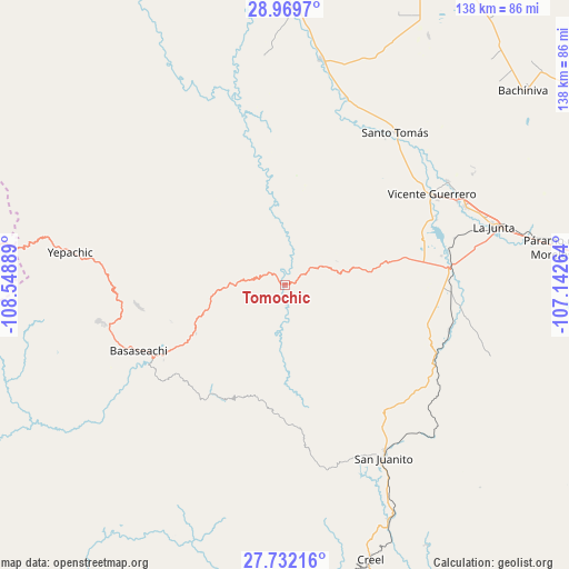
Tomochic GPS coordinates[2]
28° 21' 9.828" North, 107° 50' 44.736" West
| Map corner | latitude | longitude |
|---|---|---|
| Upper-left | 28.9697°, | -108.54889° |
| Center: | 28.35273°, | -107.84576° |
| Lower-right: | 27.73216°, | -107.14264° |
| Map W x H: | 137.6×137.6 km | = 85.5×85.5mi |
| max Lat: | 32.7° ⇑2.4% North |
| Tomochic: | 28.35273° |
| min Lat: | ⇓97.6% South 14.53588° |
| min Long | Tomochic | max Long |
| -117.105° | -107.84576° | -86.73105° |
| W 4.5%⇐ | ⇒95.5% E |
Elevation
Elevation of Tomochic is 1933 m = 6342 ft, and this is 679.3 m = 2229 ft above average elevation for this country.
| Max E: |
3497 m = 11473 ft | 29.6% |
| Tomochic | 1933 m 6342 ft | |
| Avg. | 1253.7 m = 4113 ft | |
Min E: |
-1 m = -3 ft | 70.4% |
See also: Mexico elevation on elevation.city.
Geographical zone
Tomochic is located in North temperate zone (between Tropic of Cancer and the Arctic Circle). Distance of this Northern Tropic circle is 546.6 km =339.6 mi to South.| Distance of | km | miles | from Tomochic |
|---|---|---|---|
| North Pole | 6854.5 | 4259.2 | to North |
| Arctic Circle | 4248.6 | 2640 | to North |
| Tropic Cancer | 546.6 | 339.6 | to South |
| Equator | 3152.5 | 1958.9 | to South |


Nearby cities:
15 places around Tomochic: (largest is in red/bold)
• Adolfo López Mateos
54.9 km =34.1 mi,  76°
76°
• Basaseachic
39.4 km =24.5 mi,  245°
245°
• Basúchil
47.4 km =29.5 mi,  66°
66°
• Borjas
46.2 km =28.7 mi,  64°
64°
• Cajurichic
40.1 km =24.9 mi,  225°
225°
• Guerrero
41.6 km =25.8 mi, 58°
• La Junta
52.4 km =32.6 mi, 74°
• Matachí
55.2 km =34.3 mi,  9°
9°
• Ocampo
54.1 km =33.6 mi, 250°
• Pachera
44.4 km =27.6 mi,  99°
99°
• San Juanito
48.5 km =30.1 mi,  150°
150°
• Santo Tomás
45.3 km =28.1 mi,  36°
36°
• Sáenz
50.9 km =31.6 mi, 71°
• Tacuba
36.5 km =22.7 mi,  90°
90°
• Yepachic
52.5 km =32.6 mi,  278°
278°
Sources, notices
• [Note1] Compared only with cities in Mexico existing in our database
• [Src1] Map data: © OpenStreetMap contributors (CC-BY-SA)
• [Src2] Other city data from geonames.org with taken over terms of usage.
• [Src3] Geographical zone / Annual Mean Temperature by Robert A. Rohde @ Wikipedia
