Xoconoxtle el Grande geodata
Xoconoxtle el Grande (Guanajuato) is a populated place; located in Mexico in America/Mexico_City (GMT-6) time zone. With population of 1,014 people, there are 8595 cities with bigger population in this country. Compared to other cities in Mexico, 75.5% of cities are located further ↓South; 73.3% of cities are located further →East and 72.6% of cities have lower elevation than Xoconoxtle el Grande. Note1
Administrative division(s):
- Level 1: Guanajuato
- Level 2: Dolores Hidalgo Cuna de la Independencia Nacional


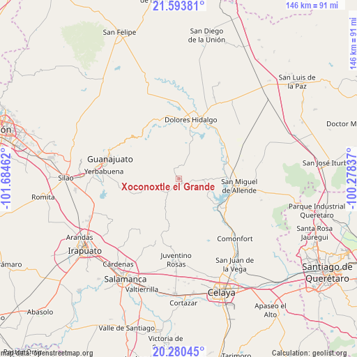
Xoconoxtle el Grande GPS coordinates[2]
20° 56' 18.852" North, 100° 58' 53.364" West
| Map corner | latitude | longitude |
|---|---|---|
| Upper-left | 21.59381°, | -101.68462° |
| Center: | 20.93857°, | -100.98149° |
| Lower-right: | 20.28045°, | -100.27837° |
| Map W x H: | 146×146 km | = 90.7×90.7mi |
| max Lat: | 32.7° ⇑24.5% North |
| Xoconoxtle el Grande: | 20.93857° |
| min Lat: | ⇓75.5% South 14.53588° |
| min Long | Xoconoxtle el G | max Long |
| -117.105° | -100.98149° | -86.73105° |
| W 26.7%⇐ | ⇒73.3% E |
Elevation
Elevation of Xoconoxtle el Grande is 1979 m = 6493 ft, and this is 725.3 m = 2380 ft above average elevation for this country.
| Max E: |
3497 m = 11473 ft | 27.4% |
| Xoconoxtle el Grande | 1979 m 6493 ft | |
| Avg. | 1253.7 m = 4113 ft | |
Min E: |
-1 m = -3 ft | 72.6% |
See also: Mexico elevation on elevation.city.
Geographical zone
Xoconoxtle el Grande is located in North Torrid zone (between Equator and Tropic of Cancer). Distance of this Northern Tropic circle is 277.8 km =172.6 mi to North.| Distance of | km | miles | from Xoconoxtle el Grande |
|---|---|---|---|
| North Pole | 7678.9 | 4771.4 | to North |
| Arctic Circle | 5073 | 3152.2 | to North |
| Tropic Cancer | 277.8 | 172.6 | to North |
| Equator | 2328.2 | 1446.7 | to South |


Nearby cities:
15 places around Xoconoxtle el Grande: (largest is in red/bold)
• Agustín González
16 km =9.9 mi,  123°
123°
• Campuzano
16.7 km =10.4 mi,  261°
261°
• Don Francisco
7.6 km =4.7 mi, 121°
• La Cantera
9.3 km =5.8 mi, 258°
• La Cruz del Palmar
14.7 km =9.1 mi,  76°
76°
• La Erre
19.3 km =12 mi,  20°
20°
• Ojo de Agua de García
17.2 km =10.7 mi,  164°
164°
• Presa Allende
18.8 km =11.7 mi, 121°
• San Damián
2.6 km =1.6 mi,  89°
89°
• San José de Allende
10.5 km =6.5 mi,  210°
210°
• San José de la Palma
17.6 km =10.9 mi,  11°
11°
• San Lucas
5.6 km =3.5 mi, 122°
• San Marcos de Abajo
9.9 km =6.2 mi,  338°
338°
• San Martín de Terreros
5.5 km =3.4 mi,  237°
237°
• Santa Bárbara
12.7 km =7.9 mi,  346°
346°
Sources, notices
• [Note1] Compared only with cities in Mexico existing in our database
• [Src1] Map data: © OpenStreetMap contributors (CC-BY-SA)
• [Src2] Other city data from geonames.org with taken over terms of usage.
• [Src3] Geographical zone / Annual Mean Temperature by Robert A. Rohde @ Wikipedia
