Tecomatán geodata
Tecomatán (Michoacán) is a populated place; located in Mexico in America/Mexico_City (GMT-6) time zone. With population of 1,096 people, there are 7931 cities with bigger population in this country. Compared to other cities in Mexico, 59.5% of cities are located further ↓South; 84.1% of cities are located further →East and 52.3% of cities have lower elevation than Tecomatán. Note1


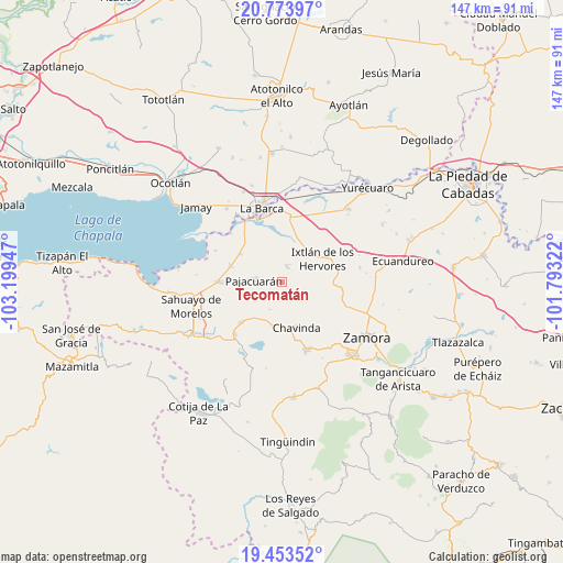
Tecomatán GPS coordinates[2]
20° 6' 54.504" North, 102° 29' 46.824" West
| Map corner | latitude | longitude |
|---|---|---|
| Upper-left | 20.77397°, | -103.19947° |
| Center: | 20.11514°, | -102.49634° |
| Lower-right: | 19.45352°, | -101.79322° |
| Map W x H: | 146.8×146.8 km | = 91.2×91.2mi |
| max Lat: | 32.7° ⇑40.5% North |
| Tecomatán: | 20.11514° |
| min Lat: | ⇓59.5% South 14.53588° |
| min Long | Tecomatán | max Long |
| -117.105° | -102.49634° | -86.73105° |
| W 15.9%⇐ | ⇒84.1% E |
Elevation
Elevation of Tecomatán is 1529 m = 5016 ft, and this is 275.3 m = 903 ft above average elevation for this country.
| Max E: |
3497 m = 11473 ft | 47.7% |
| Tecomatán | 1529 m 5016 ft | |
| Avg. | 1253.7 m = 4113 ft | |
Min E: |
-1 m = -3 ft | 52.3% |
See also: Mexico elevation on elevation.city.
Geographical zone
Tecomatán is located in North Torrid zone (between Equator and Tropic of Cancer). Distance of this Northern Tropic circle is 369.3 km =229.5 mi to North.| Distance of | km | miles | from Tecomatán |
|---|---|---|---|
| North Pole | 7770.5 | 4828.4 | to North |
| Arctic Circle | 5164.6 | 3209.1 | to North |
| Tropic Cancer | 369.3 | 229.5 | to North |
| Equator | 2236.6 | 1389.8 | to South |


Nearby cities:
15 places around Tecomatán: (largest is in red/bold)
• Camucuato
9.5 km =5.9 mi,  46°
46°
• El Limón
9.5 km =5.9 mi,  68°
68°
• El Paracho
2.9 km =1.8 mi,  254°
254°
• El Platanal
10.4 km =6.5 mi,  235°
235°
• El Tepehuaje
11.4 km =7.1 mi,  115°
115°
• El Valenciano
5.6 km =3.5 mi, 47°
• La Angostura
10.7 km =6.6 mi,  32°
32°
• La Cuestita
5.6 km =3.5 mi,  174°
174°
• La Esperanza
11.1 km =6.9 mi,  126°
126°
• La Luz
4.3 km =2.7 mi,  15°
15°
• La Plaza del Limón
7.2 km =4.5 mi, 71°
• Las Zarquillas
8.3 km =5.2 mi,  201°
201°
• Pajacuarán
7.3 km =4.5 mi,  273°
273°
• Rincón del Mezquite
8.3 km =5.2 mi,  106°
106°
• San Gregorio
10.4 km =6.5 mi,  328°
328°
Sources, notices
• [Note1] Compared only with cities in Mexico existing in our database
• [Src1] Map data: © OpenStreetMap contributors (CC-BY-SA)
• [Src2] Other city data from geonames.org with taken over terms of usage.
• [Src3] Geographical zone / Annual Mean Temperature by Robert A. Rohde @ Wikipedia
