La Luz geodata
La Luz (Michoacán) is a populated place; located in Mexico in America/Mexico_City (GMT-6) time zone. With population of 3,270 people, there are 2775 cities with bigger population in this country. Compared to other cities in Mexico, 60.3% of cities are located further ↓South; 84% of cities are located further →East and 52.4% of cities have lower elevation than La Luz. Note1


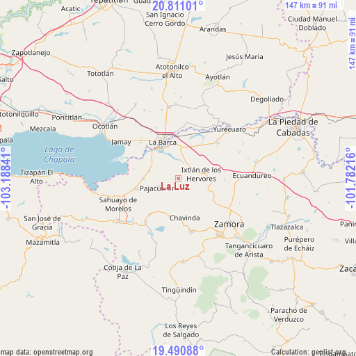
La Luz GPS coordinates[2]
20° 9' 8.424" North, 102° 29' 7.008" West
| Map corner | latitude | longitude |
|---|---|---|
| Upper-left | 20.81101°, | -103.18841° |
| Center: | 20.15234°, | -102.48528° |
| Lower-right: | 19.49088°, | -101.78216° |
| Map W x H: | 146.8×146.8 km | = 91.2×91.2mi |
| max Lat: | 32.7° ⇑39.7% North |
| La Luz: | 20.15234° |
| min Lat: | ⇓60.3% South 14.53588° |
| min Long | La Luz | max Long |
| -117.105° | -102.48528° | -86.73105° |
| W 16%⇐ | ⇒84% E |
Elevation
Elevation of La Luz is 1531 m = 5023 ft, and this is 277.3 m = 910 ft above average elevation for this country.
| Max E: |
3497 m = 11473 ft | 47.6% |
| La Luz | 1531 m 5023 ft | |
| Avg. | 1253.7 m = 4113 ft | |
Min E: |
-1 m = -3 ft | 52.4% |
See also: Mexico elevation on elevation.city.
Geographical zone
La Luz is located in North Torrid zone (between Equator and Tropic of Cancer). Distance of this Northern Tropic circle is 365.2 km =226.9 mi to North.| Distance of | km | miles | from La Luz |
|---|---|---|---|
| North Pole | 7766.3 | 4825.8 | to North |
| Arctic Circle | 5160.4 | 3206.5 | to North |
| Tropic Cancer | 365.2 | 226.9 | to North |
| Equator | 2240.7 | 1392.3 | to South |


Nearby cities:
15 places around La Luz: (largest is in red/bold)
• Camucuato
6.2 km =3.9 mi,  66°
66°
• El Capulín
8.4 km =5.2 mi,  356°
356°
• El Fortín
12.4 km =7.7 mi,  284°
284°
• El Limón
7.8 km =4.8 mi,  94°
94°
• El Paracho
6.3 km =3.9 mi,  218°
218°
• El Salitre
11.7 km =7.3 mi,  81°
81°
• El Valenciano
3 km =1.9 mi,  97°
97°
• Ixtlán de los Hervores
9.6 km =6 mi, 78°
• La Angostura
6.7 km =4.2 mi,  42°
42°
• La Cuestita
9.7 km =6 mi,  183°
183°
• La Plaza del Limón
6 km =3.7 mi,  108°
108°
• Pajacuarán
9.2 km =5.7 mi,  246°
246°
• Rincón del Mezquite
9.4 km =5.8 mi,  133°
133°
• San Gregorio
8.1 km =5 mi,  305°
305°
• Tecomatán
4.3 km =2.7 mi,  195°
195°
Sources, notices
• [Note1] Compared only with cities in Mexico existing in our database
• [Src1] Map data: © OpenStreetMap contributors (CC-BY-SA)
• [Src2] Other city data from geonames.org with taken over terms of usage.
• [Src3] Geographical zone / Annual Mean Temperature by Robert A. Rohde @ Wikipedia
