San Andrés geodata
San Andrés (Nayarit) is a populated place; located in Mexico in America/Mazatlan (GMT-7) time zone. With population of 646 people, there are 13395 cities with bigger population in this country. Compared to other cities in Mexico, 81.9% of cities are located further ↓South; 91.7% of cities are located further →East and 64.4% of cities have higher elevation than San Andrés. Note1


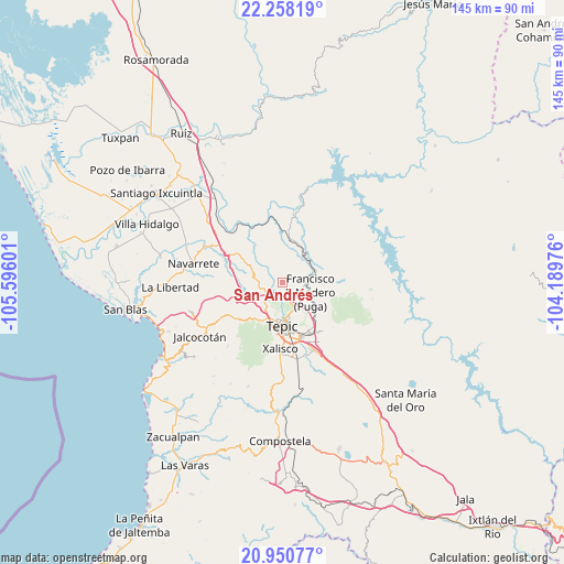
San Andrés GPS coordinates[2]
21° 36' 21.456" North, 104° 53' 34.368" West
| Map corner | latitude | longitude |
|---|---|---|
| Upper-left | 22.25819°, | -105.59601° |
| Center: | 21.60596°, | -104.89288° |
| Lower-right: | 20.95077°, | -104.18976° |
| Map W x H: | 145.4×145.4 km | = 90.3×90.3mi |
| max Lat: | 32.7° ⇑18.1% North |
| San Andrés: | 21.60596° |
| min Lat: | ⇓81.9% South 14.53588° |
| min Long | San Andrés | max Long |
| -117.105° | -104.89288° | -86.73105° |
| W 8.3%⇐ | ⇒91.7% E |
Elevation
Elevation of San Andrés is 726 m = 2382 ft, and this is 527.7 m = 1731 ft below average elevation for this country.
| Max E: |
3497 m = 11473 ft | 64.4% |
| Avg. | 1253.7 m = 4113 ft | |
| San Andrés | 726 m = 2382 ft | |
Min E: |
-1 m = -3 ft | 35.6% |
See also: Mexico elevation on elevation.city.
Geographical zone
San Andrés is located in North Torrid zone (between Equator and Tropic of Cancer). Distance of this Northern Tropic circle is 203.6 km =126.5 mi to North.| Distance of | km | miles | from San Andrés |
|---|---|---|---|
| North Pole | 7604.7 | 4725.3 | to North |
| Arctic Circle | 4998.8 | 3106.1 | to North |
| Tropic Cancer | 203.6 | 126.5 | to North |
| Equator | 2402.4 | 1492.8 | to South |


Nearby cities:
15 places around San Andrés: (largest is in red/bold)
• Atonalisco
8.6 km =5.3 mi,  39°
39°
• Bellavista
5 km =3.1 mi,  167°
167°
• El Ahuacate
11.4 km =7.1 mi,  207°
207°
• El Rincón
6.3 km =3.9 mi,  221°
221°
• El Trapichillo
10 km =6.2 mi,  248°
248°
• Francisco I. Madero
8.1 km =5 mi,  109°
109°
• Jesús María Corte
13 km =8.1 mi,  4°
4°
• La Cantera
13.6 km =8.5 mi,  147°
147°
• La Fortuna
8.4 km =5.2 mi,  225°
225°
• Lo de Lamedo
8.9 km =5.5 mi, 212°
• Mora
12.3 km =7.6 mi,  135°
135°
• Puga
7.6 km =4.7 mi, 108°
• San Fernando
11.5 km =7.1 mi, 105°
• Tepic
10.7 km =6.6 mi,  181°
181°
• Xalisco
17.2 km =10.7 mi, 181°
Sources, notices
• [Note1] Compared only with cities in Mexico existing in our database
• [Src1] Map data: © OpenStreetMap contributors (CC-BY-SA)
• [Src2] Other city data from geonames.org with taken over terms of usage.
• [Src3] Geographical zone / Annual Mean Temperature by Robert A. Rohde @ Wikipedia
