Bellavista geodata
Bellavista (Nayarit) is a populated place; located in Mexico in America/Mazatlan (GMT-7) time zone. With population of 2,291 people, there are 3846 cities with bigger population in this country. Compared to other cities in Mexico, 81.8% of cities are located further ↓South; 91.7% of cities are located further →East and 63.5% of cities have higher elevation than Bellavista. Note1


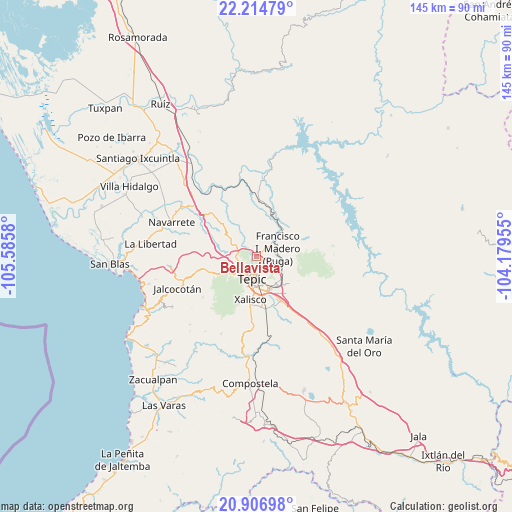
Bellavista GPS coordinates[2]
21° 33' 44.496" North, 104° 52' 57.612" West
| Map corner | latitude | longitude |
|---|---|---|
| Upper-left | 22.21479°, | -105.5858° |
| Center: | 21.56236°, | -104.88267° |
| Lower-right: | 20.90698°, | -104.17955° |
| Map W x H: | 145.4×145.4 km | = 90.3×90.3mi |
| max Lat: | 32.7° ⇑18.2% North |
| Bellavista: | 21.56236° |
| min Lat: | ⇓81.8% South 14.53588° |
| min Long | Bellavista | max Long |
| -117.105° | -104.88267° | -86.73105° |
| W 8.3%⇐ | ⇒91.7% E |
Elevation
Elevation of Bellavista is 783 m = 2569 ft, and this is 470.7 m = 1544 ft below average elevation for this country.
| Max E: |
3497 m = 11473 ft | 63.5% |
| Avg. | 1253.7 m = 4113 ft | |
| Bellavista | 783 m = 2569 ft | |
Min E: |
-1 m = -3 ft | 36.5% |
See also: Mexico elevation on elevation.city.
Geographical zone
Bellavista is located in North Torrid zone (between Equator and Tropic of Cancer). Distance of this Northern Tropic circle is 208.4 km =129.5 mi to North.| Distance of | km | miles | from Bellavista |
|---|---|---|---|
| North Pole | 7609.6 | 4728.4 | to North |
| Arctic Circle | 5003.7 | 3109.2 | to North |
| Tropic Cancer | 208.4 | 129.5 | to North |
| Equator | 2397.5 | 1489.7 | to South |


Nearby cities:
15 places around Bellavista: (largest is in red/bold)
• Atonalisco
12.3 km =7.6 mi,  21°
21°
• El Ahuacate
8.2 km =5.1 mi,  230°
230°
• El Rincón
5.2 km =3.2 mi,  271°
271°
• El Trapichillo
10.4 km =6.5 mi,  276°
276°
• El Verde
13.5 km =8.4 mi,  155°
155°
• Francisco I. Madero
6.9 km =4.3 mi,  71°
71°
• La Cantera
9.1 km =5.7 mi,  136°
136°
• La Fortuna
7.1 km =4.4 mi,  261°
261°
• Lo de Lamedo
6.4 km =4 mi,  245°
245°
• Mora
8.5 km =5.3 mi,  118°
118°
• Puga
6.6 km =4.1 mi, 68°
• San Andrés
5 km =3.1 mi,  347°
347°
• San Fernando
10.2 km =6.3 mi,  79°
79°
• Tepic
6 km =3.7 mi,  192°
192°
• Xalisco
12.5 km =7.8 mi, 187°
Sources, notices
• [Note1] Compared only with cities in Mexico existing in our database
• [Src1] Map data: © OpenStreetMap contributors (CC-BY-SA)
• [Src2] Other city data from geonames.org with taken over terms of usage.
• [Src3] Geographical zone / Annual Mean Temperature by Robert A. Rohde @ Wikipedia
