Jesús María Corte geodata
Jesús María Corte (Nayarit) is a populated place; located in Mexico in America/Mazatlan (GMT-7) time zone. With population of 643 people, there are 13457 cities with bigger population in this country. Compared to other cities in Mexico, 82.6% of cities are located further ↓South; 91.7% of cities are located further →East and 76.5% of cities have higher elevation than Jesús María Corte. Note1


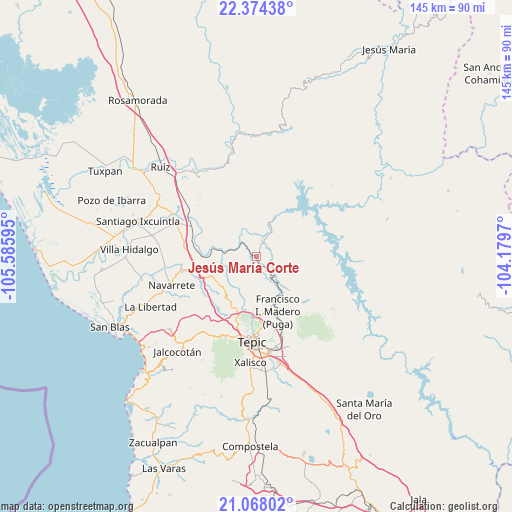
Jesús María Corte GPS coordinates[2]
21° 43' 21.648" North, 104° 52' 58.152" West
| Map corner | latitude | longitude |
|---|---|---|
| Upper-left | 22.37438°, | -105.58595° |
| Center: | 21.72268°, | -104.88282° |
| Lower-right: | 21.06802°, | -104.1797° |
| Map W x H: | 145.3×145.3 km | = 90.3×90.3mi |
| max Lat: | 32.7° ⇑17.4% North |
| Jesús María Corte: | 21.72268° |
| min Lat: | ⇓82.6% South 14.53588° |
| min Long | Jesús María C | max Long |
| -117.105° | -104.88282° | -86.73105° |
| W 8.3%⇐ | ⇒91.7% E |
Elevation
Elevation of Jesús María Corte is 169 m = 554 ft, and this is 1084.7 m = 3559 ft below average elevation for this country.
| Max E: |
3497 m = 11473 ft | 76.5% |
| Avg. | 1253.7 m = 4113 ft | |
| Jesús María Corte | 169 m = 554 ft | |
Min E: |
-1 m = -3 ft | 23.5% |
See also: Mexico elevation on elevation.city.
Geographical zone
Jesús María Corte is located in North Torrid zone (between Equator and Tropic of Cancer). Distance of this Northern Tropic circle is 190.6 km =118.4 mi to North.| Distance of | km | miles | from Jesús María Corte |
|---|---|---|---|
| North Pole | 7591.7 | 4717.3 | to North |
| Arctic Circle | 4985.8 | 3098 | to North |
| Tropic Cancer | 190.6 | 118.4 | to North |
| Equator | 2415.3 | 1500.8 | to South |


Nearby cities:
15 places around Jesús María Corte: (largest is in red/bold)
• Atonalisco
7.8 km =4.8 mi,  144°
144°
• Bellavista
17.8 km =11.1 mi,  179°
179°
• El Jicote
18.1 km =11.2 mi,  270°
270°
• El Rincón
18.4 km =11.4 mi,  196°
196°
• El Tambor
15.9 km =9.9 mi,  279°
279°
• El Trapichillo
19.6 km =12.2 mi,  211°
211°
• Estación Nanchi (Peñasquillo)
20.6 km =12.8 mi,  294°
294°
• Francisco I. Madero
17 km =10.6 mi,  157°
157°
• La Fortuna
20.1 km =12.5 mi, 200°
• Lo de Lamedo
21.3 km =13.2 mi, 195°
• Mojarritas
18.6 km =11.6 mi, 280°
• Puga
16.6 km =10.3 mi, 158°
• San Andrés
13 km =8.1 mi, 184°
• San Fernando
18.9 km =11.7 mi,  147°
147°
• Vado del Cora (Estación Pani)
12.8 km =8 mi, 277°
Sources, notices
• [Note1] Compared only with cities in Mexico existing in our database
• [Src1] Map data: © OpenStreetMap contributors (CC-BY-SA)
• [Src2] Other city data from geonames.org with taken over terms of usage.
• [Src3] Geographical zone / Annual Mean Temperature by Robert A. Rohde @ Wikipedia
