El Ahuacate geodata
El Ahuacate (Nayarit) is a populated place; located in Mexico in America/Mazatlan (GMT-7) time zone. With population of 1,148 people, there are 7555 cities with bigger population in this country. Compared to other cities in Mexico, 81.5% of cities are located further ↓South; 91.8% of cities are located further →East and 60.1% of cities have higher elevation than El Ahuacate. Note1


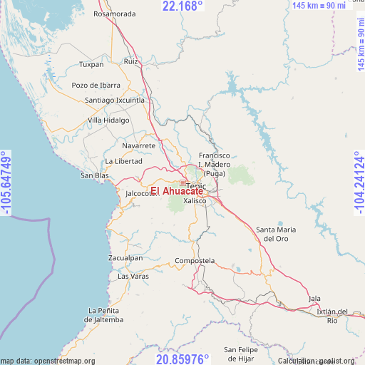
El Ahuacate GPS coordinates[2]
21° 30' 55.26" North, 104° 56' 39.696" West
| Map corner | latitude | longitude |
|---|---|---|
| Upper-left | 22.168°, | -105.64749° |
| Center: | 21.51535°, | -104.94436° |
| Lower-right: | 20.85976°, | -104.24124° |
| Map W x H: | 145.5×145.5 km | = 90.4×90.4mi |
| max Lat: | 32.7° ⇑18.5% North |
| El Ahuacate: | 21.51535° |
| min Lat: | ⇓81.5% South 14.53588° |
| min Long | El Ahuacate | max Long |
| -117.105° | -104.94436° | -86.73105° |
| W 8.2%⇐ | ⇒91.8% E |
Elevation
Elevation of El Ahuacate is 995 m = 3264 ft, and this is 258.7 m = 849 ft below average elevation for this country.
| Max E: |
3497 m = 11473 ft | 60.1% |
| Avg. | 1253.7 m = 4113 ft | |
| El Ahuacate | 995 m = 3264 ft | |
Min E: |
-1 m = -3 ft | 39.9% |
See also: Mexico elevation on elevation.city.
Geographical zone
El Ahuacate is located in North Torrid zone (between Equator and Tropic of Cancer). Distance of this Northern Tropic circle is 213.6 km =132.7 mi to North.| Distance of | km | miles | from El Ahuacate |
|---|---|---|---|
| North Pole | 7614.8 | 4731.6 | to North |
| Arctic Circle | 5008.9 | 3112.4 | to North |
| Tropic Cancer | 213.6 | 132.7 | to North |
| Equator | 2392.3 | 1486.5 | to South |


Nearby cities:
15 places around El Ahuacate: (largest is in red/bold)
• Bellavista
8.2 km =5.1 mi,  50°
50°
• Cuarenteño
10.9 km =6.8 mi,  234°
234°
• El Rincón
5.5 km =3.4 mi,  11°
11°
• El Trapichillo
7.5 km =4.7 mi,  327°
327°
• El Verde
13.9 km =8.6 mi,  120°
120°
• La Cantera
12.7 km =7.9 mi,  96°
96°
• La Fortuna
4.2 km =2.6 mi,  350°
350°
• La Yerba
10.9 km =6.8 mi,  273°
273°
• Lo de Lamedo
2.6 km =1.6 mi, 11°
• Mora
13.9 km =8.6 mi,  84°
84°
• Pantanal
13 km =8.1 mi,  138°
138°
• San Andrés
11.4 km =7.1 mi,  27°
27°
• Tepic
5.1 km =3.2 mi, 97°
• Testerazo
13.6 km =8.5 mi,  157°
157°
• Xalisco
8.6 km =5.3 mi,  146°
146°
Sources, notices
• [Note1] Compared only with cities in Mexico existing in our database
• [Src1] Map data: © OpenStreetMap contributors (CC-BY-SA)
• [Src2] Other city data from geonames.org with taken over terms of usage.
• [Src3] Geographical zone / Annual Mean Temperature by Robert A. Rohde @ Wikipedia
