La Fortuna geodata
La Fortuna (Nayarit) is a populated place; located in Mexico in America/Mazatlan (GMT-7) time zone. With population of 1,046 people, there are 8327 cities with bigger population in this country. Compared to other cities in Mexico, 81.7% of cities are located further ↓South; 91.8% of cities are located further →East and 63.1% of cities have higher elevation than La Fortuna. Note1


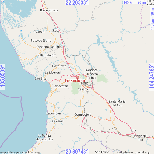
La Fortuna GPS coordinates[2]
21° 33' 10.26" North, 104° 57' 2.772" West
| Map corner | latitude | longitude |
|---|---|---|
| Upper-left | 22.20533°, | -105.6539° |
| Center: | 21.55285°, | -104.95077° |
| Lower-right: | 20.89743°, | -104.24765° |
| Map W x H: | 145.4×145.4 km | = 90.3×90.3mi |
| max Lat: | 32.7° ⇑18.3% North |
| La Fortuna: | 21.55285° |
| min Lat: | ⇓81.7% South 14.53588° |
| min Long | La Fortuna | max Long |
| -117.105° | -104.95077° | -86.73105° |
| W 8.2%⇐ | ⇒91.8% E |
Elevation
Elevation of La Fortuna is 808 m = 2651 ft, and this is 445.7 m = 1462 ft below average elevation for this country.
| Max E: |
3497 m = 11473 ft | 63.1% |
| Avg. | 1253.7 m = 4113 ft | |
| La Fortuna | 808 m = 2651 ft | |
Min E: |
-1 m = -3 ft | 36.9% |
See also: Mexico elevation on elevation.city.
Geographical zone
La Fortuna is located in North Torrid zone (between Equator and Tropic of Cancer). Distance of this Northern Tropic circle is 209.5 km =130.2 mi to North.| Distance of | km | miles | from La Fortuna |
|---|---|---|---|
| North Pole | 7610.6 | 4729 | to North |
| Arctic Circle | 5004.7 | 3109.8 | to North |
| Tropic Cancer | 209.5 | 130.2 | to North |
| Equator | 2396.5 | 1489.1 | to South |


Nearby cities:
15 places around La Fortuna: (largest is in red/bold)
• Bellavista
7.1 km =4.4 mi,  81°
81°
• Cuarenteño
13.3 km =8.3 mi,  217°
217°
• El Ahuacate
4.2 km =2.6 mi,  170°
170°
• El Rincón
2.2 km =1.4 mi,  55°
55°
• El Trapichillo
4 km =2.5 mi,  303°
303°
• Francisco I. Madero
14 km =8.7 mi, 76°
• La Cantera
14.4 km =8.9 mi,  112°
112°
• La Yerba
10.8 km =6.7 mi,  251°
251°
• Lo de Lamedo
2 km =1.2 mi,  143°
143°
• Mora
14.8 km =9.2 mi,  101°
101°
• Pantanal
16.7 km =10.4 mi,  146°
146°
• Puga
13.7 km =8.5 mi, 75°
• San Andrés
8.4 km =5.2 mi,  45°
45°
• Tepic
7.5 km =4.7 mi,  130°
130°
• Xalisco
12.6 km =7.8 mi, 154°
Sources, notices
• [Note1] Compared only with cities in Mexico existing in our database
• [Src1] Map data: © OpenStreetMap contributors (CC-BY-SA)
• [Src2] Other city data from geonames.org with taken over terms of usage.
• [Src3] Geographical zone / Annual Mean Temperature by Robert A. Rohde @ Wikipedia
