Pesqueira geodata
Pesqueira (Sonora) is a populated place; located in Mexico in America/Hermosillo (GMT-7) time zone. With population of 5,699 people, there are 1632 cities with bigger population in this country. Compared to other cities in Mexico, 98.2% of cities are located further ↓South; 98.6% of cities are located further →East and 72.1% of cities have higher elevation than Pesqueira. Note1


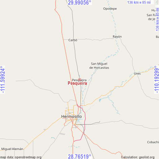
Pesqueira GPS coordinates[2]
29° 22' 46.992" North, 110° 53' 45.996" West
| Map corner | latitude | longitude |
|---|---|---|
| Upper-left | 29.99056°, | -111.59924° |
| Center: | 29.37972°, | -110.89611° |
| Lower-right: | 28.76519°, | -110.19299° |
| Map W x H: | 136.2×136.2 km | = 84.6×84.6mi |
| max Lat: | 32.7° ⇑1.8% North |
| Pesqueira: | 29.37972° |
| min Lat: | ⇓98.2% South 14.53588° |
| min Long | Pesqueira | max Long |
| -117.105° | -110.89611° | -86.73105° |
| W 1.4%⇐ | ⇒98.6% E |
Elevation
Elevation of Pesqueira is 326 m = 1070 ft, and this is 927.7 m = 3044 ft below average elevation for this country.
| Max E: |
3497 m = 11473 ft | 72.1% |
| Avg. | 1253.7 m = 4113 ft | |
| Pesqueira | 326 m = 1070 ft | |
Min E: |
-1 m = -3 ft | 27.9% |
See also: Mexico elevation on elevation.city.
Geographical zone
Pesqueira is located in North temperate zone (between Tropic of Cancer and the Arctic Circle). Distance of this Northern Tropic circle is 660.8 km =410.6 mi to South.| Distance of | km | miles | from Pesqueira |
|---|---|---|---|
| North Pole | 6740.3 | 4188.2 | to North |
| Arctic Circle | 4134.5 | 2569.1 | to North |
| Tropic Cancer | 660.8 | 410.6 | to South |
| Equator | 3266.7 | 2029.8 | to South |


Nearby cities:
15 places around Pesqueira: (largest is in red/bold)
• Alejandro Carrillo Marcor
67 km =41.6 mi,  219°
219°
• Carbo
34.2 km =21.3 mi,  350°
350°
• El Alamito Buenavista
22.8 km =14.2 mi,  169°
169°
• Estación Zamora
13.2 km =8.2 mi,  175°
175°
• Guadalupe
43.3 km =26.9 mi,  89°
89°
• Hermosillo
31.8 km =19.8 mi,  194°
194°
• La Colorada
71.1 km =44.2 mi,  154°
154°
• La Victoria
28.6 km =17.8 mi, 178°
• Las Mercedes [Agropecuaria]
5.7 km =3.5 mi,  251°
251°
• Molino de Camou
23.7 km =14.7 mi, 145°
• Opodepe
66 km =41 mi,  23°
23°
• Rayón
48.7 km =30.3 mi,  40°
40°
• San Miguel de Horcasitas
20.5 km =12.7 mi,  54°
54°
• Santa Inés Uno (El Capitán)
68.4 km =42.5 mi,  240°
240°
• Ures
49.5 km =30.8 mi,  83°
83°
Sources, notices
• [Note1] Compared only with cities in Mexico existing in our database
• [Src1] Map data: © OpenStreetMap contributors (CC-BY-SA)
• [Src2] Other city data from geonames.org with taken over terms of usage.
• [Src3] Geographical zone / Annual Mean Temperature by Robert A. Rohde @ Wikipedia
