Rayón geodata
Rayón (Sonora) is a seat of a second-order administrative division; located in Mexico in America/Hermosillo (GMT-7) time zone. With population of 1,382 people, there are 6268 cities with bigger population in this country. Compared to other cities in Mexico, 98.4% of cities are located further ↓South; 98.4% of cities are located further →East and 67.6% of cities have higher elevation than Rayón. Note1


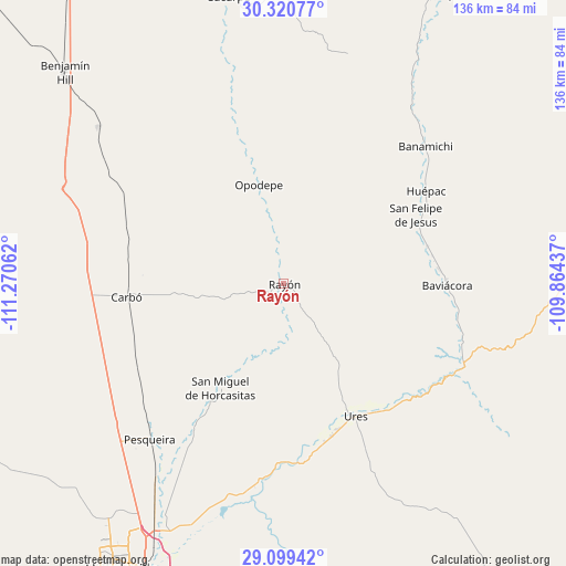
Rayón GPS coordinates[2]
29° 42' 43.02" North, 110° 34' 2.964" West
| Map corner | latitude | longitude |
|---|---|---|
| Upper-left | 30.32077°, | -111.27062° |
| Center: | 29.71195°, | -110.56749° |
| Lower-right: | 29.09942°, | -109.86437° |
| Map W x H: | 135.8×135.8 km | = 84.4×84.4mi |
| max Lat: | 32.7° ⇑1.6% North |
| Rayón: | 29.71195° |
| min Lat: | ⇓98.4% South 14.53588° |
| min Long | Rayón | max Long |
| -117.105° | -110.56749° | -86.73105° |
| W 1.6%⇐ | ⇒98.4% E |
Elevation
Elevation of Rayón is 547 m = 1795 ft, and this is 706.7 m = 2319 ft below average elevation for this country.
| Max E: |
3497 m = 11473 ft | 67.6% |
| Avg. | 1253.7 m = 4113 ft | |
| Rayón | 547 m = 1795 ft | |
Min E: |
-1 m = -3 ft | 32.4% |
See also: Mexico elevation on elevation.city.
Geographical zone
Rayón is located in North temperate zone (between Tropic of Cancer and the Arctic Circle). Distance of this Northern Tropic circle is 697.7 km =433.5 mi to South.| Distance of | km | miles | from Rayón |
|---|---|---|---|
| North Pole | 6703.4 | 4165.3 | to North |
| Arctic Circle | 4097.5 | 2546.1 | to North |
| Tropic Cancer | 697.7 | 433.5 | to South |
| Equator | 3303.7 | 2052.8 | to South |


Nearby cities:
15 places around Rayón: (largest is in red/bold)
• Aconchi
35.4 km =22 mi,  68°
68°
• Banámichi
47.2 km =29.3 mi,  45°
45°
• Baviácora
39.1 km =24.3 mi,  89°
89°
• Carbo
37.7 km =23.4 mi,  265°
265°
• Estación Zamora
58.9 km =36.6 mi,  211°
211°
• Guadalupe
38.2 km =23.7 mi,  162°
162°
• Huépac
40.7 km =25.3 mi,  57°
57°
• La Estancia
35.7 km =22.2 mi,  75°
75°
• Las Mercedes [Agropecuaria]
53.7 km =33.4 mi,  223°
223°
• Opodepe
24.5 km =15.2 mi,  345°
345°
• Pesqueira
48.7 km =30.3 mi, 220°
• Querobabi
58.1 km =36.1 mi,  310°
310°
• San Felipe de Jesús
35.9 km =22.3 mi, 62°
• San Miguel de Horcasitas
29.2 km =18.1 mi, 211°
• Ures
36.1 km =22.4 mi,  151°
151°
Sources, notices
• [Note1] Compared only with cities in Mexico existing in our database
• [Src1] Map data: © OpenStreetMap contributors (CC-BY-SA)
• [Src2] Other city data from geonames.org with taken over terms of usage.
• [Src3] Geographical zone / Annual Mean Temperature by Robert A. Rohde @ Wikipedia
