Opodepe geodata
Opodepe (Sonora) is a seat of a second-order administrative division; located in Mexico in America/Hermosillo (GMT-7) time zone. With population of 344 people, there are 16861 cities with bigger population in this country. Compared to other cities in Mexico, 98.5% of cities are located further ↓South; 98.4% of cities are located further →East and 65.7% of cities have higher elevation than Opodepe. Note1


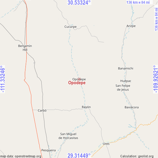
Opodepe GPS coordinates[2]
29° 55' 32.628" North, 110° 37' 45.588" West
| Map corner | latitude | longitude |
|---|---|---|
| Upper-left | 30.53324°, | -111.33246° |
| Center: | 29.92573°, | -110.62933° |
| Lower-right: | 29.31449°, | -109.92621° |
| Map W x H: | 135.5×135.5 km | = 84.2×84.2mi |
| max Lat: | 32.7° ⇑1.5% North |
| Opodepe: | 29.92573° |
| min Lat: | ⇓98.5% South 14.53588° |
| min Long | Opodepe | max Long |
| -117.105° | -110.62933° | -86.73105° |
| W 1.6%⇐ | ⇒98.4% E |
Elevation
Elevation of Opodepe is 654 m = 2146 ft, and this is 599.7 m = 1968 ft below average elevation for this country.
| Max E: |
3497 m = 11473 ft | 65.7% |
| Avg. | 1253.7 m = 4113 ft | |
| Opodepe | 654 m = 2146 ft | |
Min E: |
-1 m = -3 ft | 34.3% |
See also: Mexico elevation on elevation.city.
Geographical zone
Opodepe is located in North temperate zone (between Tropic of Cancer and the Arctic Circle). Distance of this Northern Tropic circle is 721.5 km =448.3 mi to South.| Distance of | km | miles | from Opodepe |
|---|---|---|---|
| North Pole | 6679.6 | 4150.5 | to North |
| Arctic Circle | 4073.7 | 2531.3 | to North |
| Tropic Cancer | 721.5 | 448.3 | to South |
| Equator | 3327.4 | 2067.5 | to South |


Nearby cities:
15 places around Opodepe: (largest is in red/bold)
• Aconchi
40.5 km =25.2 mi,  105°
105°
• Arizpe
63.8 km =39.6 mi,  44°
44°
• Banámichi
40.9 km =25.4 mi,  77°
77°
• Baviácora
50.8 km =31.6 mi,  117°
117°
• Benjamín Hill
53.9 km =33.5 mi,  300°
300°
• Carbo
41.5 km =25.8 mi,  229°
229°
• Cucurpe
45.6 km =28.3 mi,  350°
350°
• Guadalupe
62.7 km =39 mi,  163°
163°
• Huépac
40.1 km =24.9 mi,  92°
92°
• La Estancia
43.1 km =26.8 mi, 109°
• Querobabi
40.7 km =25.3 mi,  289°
289°
• Rayón
24.5 km =15.2 mi,  165°
165°
• San Felipe de Jesús
38.4 km =23.9 mi,  100°
100°
• San Miguel de Horcasitas
49.6 km =30.8 mi,  190°
190°
• Ures
60.2 km =37.4 mi, 157°
Sources, notices
• [Note1] Compared only with cities in Mexico existing in our database
• [Src1] Map data: © OpenStreetMap contributors (CC-BY-SA)
• [Src2] Other city data from geonames.org with taken over terms of usage.
• [Src3] Geographical zone / Annual Mean Temperature by Robert A. Rohde @ Wikipedia
