Pénjamo geodata
Pénjamo (Guanajuato) is a seat of a second-order administrative division; located in Mexico in America/Mexico_City (GMT-6) time zone. With population of 40,070 people, there are 262 cities with bigger population in this country. Compared to other cities in Mexico, 66.3% of cities are located further ↓South; 79.2% of cities are located further →East and 62.6% of cities have lower elevation than Pénjamo. Note1


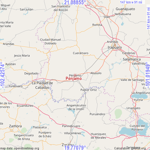
Pénjamo GPS coordinates[2]
20° 25' 51.888" North, 101° 43' 21.396" West
| Map corner | latitude | longitude |
|---|---|---|
| Upper-left | 21.08855°, | -102.42574° |
| Center: | 20.43108°, | -101.72261° |
| Lower-right: | 19.77079°, | -101.01949° |
| Map W x H: | 146.5×146.5 km | = 91×91mi |
| max Lat: | 32.7° ⇑33.7% North |
| Pénjamo: | 20.43108° |
| min Lat: | ⇓66.3% South 14.53588° |
| min Long | Pénjamo | max Long |
| -117.105° | -101.72261° | -86.73105° |
| W 20.8%⇐ | ⇒79.2% E |
Elevation
Elevation of Pénjamo is 1771 m = 5810 ft, and this is 517.3 m = 1697 ft above average elevation for this country.
| Max E: |
3497 m = 11473 ft | 37.4% |
| Pénjamo | 1771 m 5810 ft | |
| Avg. | 1253.7 m = 4113 ft | |
Min E: |
-1 m = -3 ft | 62.6% |
See also: Pénjamo elevation on elevation.city.
Geographical zone
Pénjamo is located in North Torrid zone (between Equator and Tropic of Cancer). Distance of this Northern Tropic circle is 334.2 km =207.7 mi to North.| Distance of | km | miles | from Pénjamo |
|---|---|---|---|
| North Pole | 7735.3 | 4806.5 | to North |
| Arctic Circle | 5129.5 | 3187.3 | to North |
| Tropic Cancer | 334.2 | 207.7 | to North |
| Equator | 2271.7 | 1411.6 | to South |


Nearby cities:
15 places around Pénjamo: (largest is in red/bold)
• Churipitzeo
2.9 km =1.8 mi,  223°
223°
• Colorado de Saavedra
8.8 km =5.5 mi,  199°
199°
• El Pedregal de Arriba
3.8 km =2.4 mi,  153°
153°
• El Volantín
6.3 km =3.9 mi,  283°
283°
• Estación Pénjamo
5.2 km =3.2 mi,  141°
141°
• Guangüitiro
5.5 km =3.4 mi, 283°
• La Granjena
7.7 km =4.8 mi,  121°
121°
• La Troja (El Chiflido)
6.9 km =4.3 mi, 144°
• Las Ánimas
8.9 km =5.5 mi,  244°
244°
• Magallanes
4.5 km =2.8 mi,  37°
37°
• Purísima de Ramírez (Los Oriones)
8.6 km =5.3 mi,  88°
88°
• Rancho Seco de Barajas
8.4 km =5.2 mi,  155°
155°
• San Antonio de Aguirre (San Vicente)
7.7 km =4.8 mi,  182°
182°
• Zapote de Barajas
6.6 km =4.1 mi, 158°
• Zapote de Cestao
7.6 km =4.7 mi, 39°
Sources, notices
• [Note1] Compared only with cities in Mexico existing in our database
• [Src1] Map data: © OpenStreetMap contributors (CC-BY-SA)
• [Src2] Other city data from geonames.org with taken over terms of usage.
• [Src3] Geographical zone / Annual Mean Temperature by Robert A. Rohde @ Wikipedia
