El Volantín geodata
El Volantín (Guanajuato) is a populated place; located in Mexico in America/Mexico_City (GMT-6) time zone. With population of 675 people, there are 12870 cities with bigger population in this country. Compared to other cities in Mexico, 66.6% of cities are located further ↓South; 79.6% of cities are located further →East and 69.6% of cities have lower elevation than El Volantín. Note1


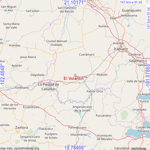
El Volantín GPS coordinates[2]
20° 26' 39.48" North, 101° 46' 54.372" West
| Map corner | latitude | longitude |
|---|---|---|
| Upper-left | 21.10171°, | -102.4849° |
| Center: | 20.4443°, | -101.78177° |
| Lower-right: | 19.78406°, | -101.07865° |
| Map W x H: | 146.5×146.5 km | = 91×91mi |
| max Lat: | 32.7° ⇑33.4% North |
| El Volantín: | 20.4443° |
| min Lat: | ⇓66.6% South 14.53588° |
| min Long | El Volantín | max Long |
| -117.105° | -101.78177° | -86.73105° |
| W 20.4%⇐ | ⇒79.6% E |
Elevation
Elevation of El Volantín is 1918 m = 6293 ft, and this is 664.3 m = 2179 ft above average elevation for this country.
| Max E: |
3497 m = 11473 ft | 30.4% |
| El Volantín | 1918 m 6293 ft | |
| Avg. | 1253.7 m = 4113 ft | |
Min E: |
-1 m = -3 ft | 69.6% |
See also: Mexico elevation on elevation.city.
Geographical zone
El Volantín is located in North Torrid zone (between Equator and Tropic of Cancer). Distance of this Northern Tropic circle is 332.7 km =206.7 mi to North.| Distance of | km | miles | from El Volantín |
|---|---|---|---|
| North Pole | 7733.9 | 4805.6 | to North |
| Arctic Circle | 5128 | 3186.4 | to North |
| Tropic Cancer | 332.7 | 206.7 | to North |
| Equator | 2273.2 | 1412.5 | to South |


Nearby cities:
15 places around El Volantín: (largest is in red/bold)
• Aratzipu
10.4 km =6.5 mi,  243°
243°
• Buenavista de Cortés
12.1 km =7.5 mi,  229°
229°
• Churipitzeo
5.5 km =3.4 mi,  131°
131°
• Colorado de Saavedra
10.3 km =6.4 mi,  162°
162°
• El Pedregal de Arriba
9.3 km =5.8 mi,  121°
121°
• Estación Pénjamo
10.9 km =6.8 mi, 120°
• Guangüitiro
0.8 km =0.5 mi,  104°
104°
• Las Ánimas
5.6 km =3.5 mi,  199°
199°
• Magallanes
9.1 km =5.7 mi,  76°
76°
• Palo Alto de Abajo
9 km =5.6 mi, 197°
• Pénjamo
6.3 km =3.9 mi, 103°
• San Antonio de Aguirre (San Vicente)
10.8 km =6.7 mi,  147°
147°
• San Bernardo
11.8 km =7.3 mi,  214°
214°
• Zapote de Barajas
11.5 km =7.1 mi, 131°
• Zapote de Cestao
11.9 km =7.4 mi,  68°
68°
Sources, notices
• [Note1] Compared only with cities in Mexico existing in our database
• [Src1] Map data: © OpenStreetMap contributors (CC-BY-SA)
• [Src2] Other city data from geonames.org with taken over terms of usage.
• [Src3] Geographical zone / Annual Mean Temperature by Robert A. Rohde @ Wikipedia
