Guangüitiro geodata
Guangüitiro (Guanajuato) is a populated place; located in Mexico in America/Mexico_City (GMT-6) time zone. With population of 640 people, there are 13529 cities with bigger population in this country. Compared to other cities in Mexico, 66.6% of cities are located further ↓South; 79.6% of cities are located further →East and 67.4% of cities have lower elevation than Guangüitiro. Note1


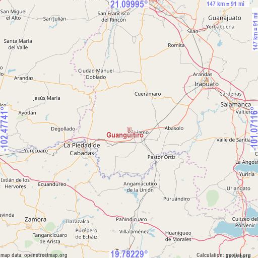
Guangüitiro GPS coordinates[2]
20° 26' 33.108" North, 101° 46' 27.408" West
| Map corner | latitude | longitude |
|---|---|---|
| Upper-left | 21.09995°, | -102.47741° |
| Center: | 20.44253°, | -101.77428° |
| Lower-right: | 19.78229°, | -101.07116° |
| Map W x H: | 146.5×146.5 km | = 91×91mi |
| max Lat: | 32.7° ⇑33.4% North |
| Guangüitiro: | 20.44253° |
| min Lat: | ⇓66.6% South 14.53588° |
| min Long | Guangüitiro | max Long |
| -117.105° | -101.77428° | -86.73105° |
| W 20.4%⇐ | ⇒79.6% E |
Elevation
Elevation of Guangüitiro is 1877 m = 6158 ft, and this is 623.3 m = 2045 ft above average elevation for this country.
| Max E: |
3497 m = 11473 ft | 32.6% |
| Guangüitiro | 1877 m 6158 ft | |
| Avg. | 1253.7 m = 4113 ft | |
Min E: |
-1 m = -3 ft | 67.4% |
See also: Mexico elevation on elevation.city.
Geographical zone
Guangüitiro is located in North Torrid zone (between Equator and Tropic of Cancer). Distance of this Northern Tropic circle is 332.9 km =206.9 mi to North.| Distance of | km | miles | from Guangüitiro |
|---|---|---|---|
| North Pole | 7734.1 | 4805.7 | to North |
| Arctic Circle | 5128.2 | 3186.5 | to North |
| Tropic Cancer | 332.9 | 206.9 | to North |
| Equator | 2273 | 1412.4 | to South |


Nearby cities:
15 places around Guangüitiro: (largest is in red/bold)
• Aratzipu
11 km =6.8 mi,  246°
246°
• Churipitzeo
4.8 km =3 mi,  135°
135°
• Colorado de Saavedra
9.9 km =6.2 mi,  165°
165°
• El Pedregal de Arriba
8.5 km =5.3 mi,  123°
123°
• El Volantín
0.8 km =0.5 mi,  284°
284°
• Estación Pénjamo
10.1 km =6.3 mi, 121°
• La Troja (El Chiflido)
11.7 km =7.3 mi,  126°
126°
• Las Ánimas
5.7 km =3.5 mi,  207°
207°
• Magallanes
8.4 km =5.2 mi,  74°
74°
• Palo Alto de Abajo
9.1 km =5.7 mi,  202°
202°
• Pénjamo
5.5 km =3.4 mi,  103°
103°
• San Antonio de Aguirre (San Vicente)
10.3 km =6.4 mi,  150°
150°
• San Bernardo
12.1 km =7.5 mi,  217°
217°
• Zapote de Barajas
10.8 km =6.7 mi, 133°
• Zapote de Cestao
11.2 km =7 mi, 65°
Sources, notices
• [Note1] Compared only with cities in Mexico existing in our database
• [Src1] Map data: © OpenStreetMap contributors (CC-BY-SA)
• [Src2] Other city data from geonames.org with taken over terms of usage.
• [Src3] Geographical zone / Annual Mean Temperature by Robert A. Rohde @ Wikipedia
