Lombardía geodata
Lombardía (Michoacán) is a populated place; located in Mexico in America/Mexico_City (GMT-6) time zone. With population of 12,610 people, there are 773 cities with bigger population in this country. Compared to other cities in Mexico, 62% of cities are located further ↑North; 81.2% of cities are located further →East and 65.7% of cities have higher elevation than Lombardía. Note1


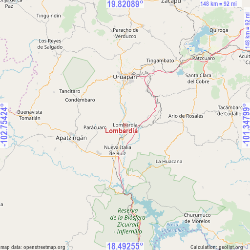
Lombardía GPS coordinates[2]
19° 9' 29.016" North, 102° 3' 3.996" West
| Map corner | latitude | longitude |
|---|---|---|
| Upper-left | 19.82089°, | -102.75424° |
| Center: | 19.15806°, | -102.05111° |
| Lower-right: | 18.49255°, | -101.34799° |
| Map W x H: | 147.7×147.7 km | = 91.8×91.8mi |
| max Lat: | 32.7° ⇑62% North |
| Lombardía: | 19.15806° |
| min Lat: | ⇓38% South 14.53588° |
| min Long | Lombardía | max Long |
| -117.105° | -102.05111° | -86.73105° |
| W 18.8%⇐ | ⇒81.2% E |
Elevation
Elevation of Lombardía is 654 m = 2146 ft, and this is 599.7 m = 1968 ft below average elevation for this country.
| Max E: |
3497 m = 11473 ft | 65.7% |
| Avg. | 1253.7 m = 4113 ft | |
| Lombardía | 654 m = 2146 ft | |
Min E: |
-1 m = -3 ft | 34.3% |
See also: Mexico elevation on elevation.city.
Geographical zone
Lombardía is located in North Torrid zone (between Equator and Tropic of Cancer). Distance of this Northern Tropic circle is 475.7 km =295.6 mi to North.| Distance of | km | miles | from Lombardía |
|---|---|---|---|
| North Pole | 7876.9 | 4894.5 | to North |
| Arctic Circle | 5271 | 3275.2 | to North |
| Tropic Cancer | 475.7 | 295.6 | to North |
| Equator | 2130.2 | 1323.6 | to South |


Nearby cities:
15 places around Lombardía: (largest is in red/bold)
• Buenos Aires
16.4 km =10.2 mi,  235°
235°
• Charapendo
11.9 km =7.4 mi,  352°
352°
• El Caulote
9.3 km =5.8 mi,  246°
246°
• El Guaco
10.1 km =6.3 mi,  183°
183°
• El Sabino
17.1 km =10.6 mi,  29°
29°
• Estación Nueva Italia
10.8 km =6.7 mi,  200°
200°
• La Estancia
14.6 km =9.1 mi,  293°
293°
• La Ibérica (La Gotera)
14.2 km =8.8 mi,  87°
87°
• Los Bancos
16.6 km =10.3 mi,  279°
279°
• Los Cajones
15.6 km =9.7 mi,  68°
68°
• Nueva Italia de Ruiz
15.4 km =9.6 mi, 196°
• Nuevo Urecho
19.2 km =11.9 mi, 87°
• Paracuaro
17.6 km =10.9 mi,  266°
266°
• Santa Casilda
10.2 km =6.3 mi, 93°
• Villa Eréndira
16.9 km =10.5 mi,  83°
83°
Sources, notices
• [Note1] Compared only with cities in Mexico existing in our database
• [Src1] Map data: © OpenStreetMap contributors (CC-BY-SA)
• [Src2] Other city data from geonames.org with taken over terms of usage.
• [Src3] Geographical zone / Annual Mean Temperature by Robert A. Rohde @ Wikipedia
