Palmillas geodata
Palmillas (Zacatecas) is a populated place; located in Mexico in America/Mexico_City (GMT-6) time zone. With population of 815 people, there are 10718 cities with bigger population in this country. Compared to other cities in Mexico, 87.2% of cities are located further ↓South; 83.3% of cities are located further →East and 80.4% of cities have lower elevation than Palmillas. Note1


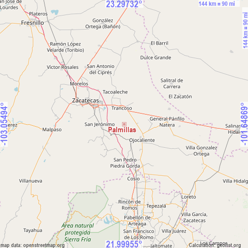
Palmillas GPS coordinates[2]
22° 38' 59.892" North, 102° 21' 6.516" West
| Map corner | latitude | longitude |
|---|---|---|
| Upper-left | 23.29732°, | -103.05494° |
| Center: | 22.64997°, | -102.35181° |
| Lower-right: | 21.99955°, | -101.64869° |
| Map W x H: | 144.3×144.3 km | = 89.7×89.7mi |
| max Lat: | 32.7° ⇑12.8% North |
| Palmillas: | 22.64997° |
| min Lat: | ⇓87.2% South 14.53588° |
| min Long | Palmillas | max Long |
| -117.105° | -102.35181° | -86.73105° |
| W 16.7%⇐ | ⇒83.3% E |
Elevation
Elevation of Palmillas is 2151 m = 7057 ft, and this is 897.3 m = 2944 ft above average elevation for this country.
| Max E: |
3497 m = 11473 ft | 19.6% |
| Palmillas | 2151 m 7057 ft | |
| Avg. | 1253.7 m = 4113 ft | |
Min E: |
-1 m = -3 ft | 80.4% |
See also: Mexico elevation on elevation.city.
Geographical zone
Palmillas is located in North Torrid zone (between Equator and Tropic of Cancer). Distance of this Northern Tropic circle is 87.5 km =54.4 mi to North.| Distance of | km | miles | from Palmillas |
|---|---|---|---|
| North Pole | 7488.6 | 4653.2 | to North |
| Arctic Circle | 4882.7 | 3034 | to North |
| Tropic Cancer | 87.5 | 54.4 | to North |
| Equator | 2518.4 | 1564.9 | to South |


Nearby cities:
15 places around Palmillas: (largest is in red/bold)
• Cerrito de la Cruz
8.2 km =5.1 mi,  83°
83°
• Cieneguitas
16.1 km =10 mi,  296°
296°
• El Refugio
4.7 km =2.9 mi,  146°
146°
• La Blanquita
15.7 km =9.8 mi,  350°
350°
• La Capilla
12.4 km =7.7 mi,  70°
70°
• La Zacatecana
15.5 km =9.6 mi,  305°
305°
• Piedra Gorda
16 km =9.9 mi,  172°
172°
• Pozo de Jarillas
15.8 km =9.8 mi,  88°
88°
• San Cristóbal
13.8 km =8.6 mi,  118°
118°
• San Jerónimo
14.4 km =8.9 mi,  271°
271°
• San José del Carmen
15.2 km =9.4 mi,  31°
31°
• Santa Mónica
13.7 km =8.5 mi,  328°
328°
• Tlacotes
8.7 km =5.4 mi, 167°
• Trancoso
9.6 km =6 mi, 350°
• Zoquite
16.7 km =10.4 mi, 334°
Sources, notices
• [Note1] Compared only with cities in Mexico existing in our database
• [Src1] Map data: © OpenStreetMap contributors (CC-BY-SA)
• [Src2] Other city data from geonames.org with taken over terms of usage.
• [Src3] Geographical zone / Annual Mean Temperature by Robert A. Rohde @ Wikipedia
