Opopeo geodata
Opopeo (Michoacán) is a populated place; located in Mexico in America/Mexico_City (GMT-6) time zone. With population of 10,055 people, there are 945 cities with bigger population in this country. Compared to other cities in Mexico, 56% of cities are located further ↑North; 78.2% of cities are located further →East and 84.3% of cities have lower elevation than Opopeo. Note1


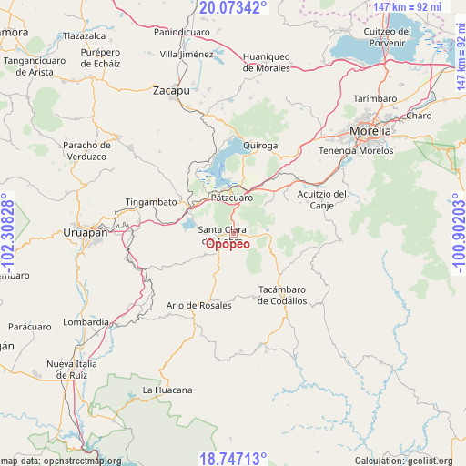
Opopeo GPS coordinates[2]
19° 24' 41.868" North, 101° 36' 18.54" West
| Map corner | latitude | longitude |
|---|---|---|
| Upper-left | 20.07342°, | -102.30828° |
| Center: | 19.41163°, | -101.60515° |
| Lower-right: | 18.74713°, | -100.90203° |
| Map W x H: | 147.5×147.5 km | = 91.7×91.7mi |
| max Lat: | 32.7° ⇑56% North |
| Opopeo: | 19.41163° |
| min Lat: | ⇓44% South 14.53588° |
| min Long | Opopeo | max Long |
| -117.105° | -101.60515° | -86.73105° |
| W 21.8%⇐ | ⇒78.2% E |
Elevation
Elevation of Opopeo is 2249 m = 7379 ft, and this is 995.3 m = 3265 ft above average elevation for this country.
| Max E: |
3497 m = 11473 ft | 15.7% |
| Opopeo | 2249 m 7379 ft | |
| Avg. | 1253.7 m = 4113 ft | |
Min E: |
-1 m = -3 ft | 84.3% |
See also: Mexico elevation on elevation.city.
Geographical zone
Opopeo is located in North Torrid zone (between Equator and Tropic of Cancer). Distance of this Northern Tropic circle is 447.5 km =278.1 mi to North.| Distance of | km | miles | from Opopeo |
|---|---|---|---|
| North Pole | 7848.7 | 4877 | to North |
| Arctic Circle | 5242.8 | 3257.7 | to North |
| Tropic Cancer | 447.5 | 278.1 | to North |
| Equator | 2158.4 | 1341.2 | to South |


Nearby cities:
15 places around Opopeo: (largest is in red/bold)
• Camémbaro
11.2 km =7 mi,  206°
206°
• Chapa
7.3 km =4.5 mi,  240°
240°
• Colonia Vista Bella (Lomas del Peaje)
8.9 km =5.5 mi,  7°
7°
• Cuanajo
13 km =8.1 mi,  51°
51°
• Cuitzitán
7.3 km =4.5 mi,  220°
220°
• El Refugio
13.7 km =8.5 mi,  61°
61°
• El Tepetate
5 km =3.1 mi,  150°
150°
• Joya de los Molinos
8.8 km =5.5 mi,  2°
2°
• Parahuén
11.3 km =7 mi,  233°
233°
• Pátzcuaro
11.6 km =7.2 mi,  358°
358°
• San Gregorio
7 km =4.3 mi,  98°
98°
• San Miguel Charahuén
11.9 km =7.4 mi,  302°
302°
• Santa Clara del Cobre
3.7 km =2.3 mi,  259°
259°
• Santa Juana
5.1 km =3.2 mi,  65°
65°
• Turirán
6.4 km =4 mi,  174°
174°
Sources, notices
• [Note1] Compared only with cities in Mexico existing in our database
• [Src1] Map data: © OpenStreetMap contributors (CC-BY-SA)
• [Src2] Other city data from geonames.org with taken over terms of usage.
• [Src3] Geographical zone / Annual Mean Temperature by Robert A. Rohde @ Wikipedia
