El Refugio geodata
El Refugio (Michoacán) is a populated place; located in Mexico in America/Mexico_City (GMT-6) time zone. With population of 555 people, there are 15371 cities with bigger population in this country. Compared to other cities in Mexico, 54.7% of cities are located further ↑North; 77.3% of cities are located further →East and 89.6% of cities have lower elevation than El Refugio. Note1


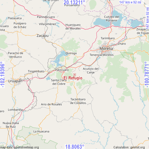
El Refugio GPS coordinates[2]
19° 28' 14.016" North, 101° 29' 26.988" West
| Map corner | latitude | longitude |
|---|---|---|
| Upper-left | 20.13211°, | -102.19396° |
| Center: | 19.47056°, | -101.49083° |
| Lower-right: | 18.8063°, | -100.78771° |
| Map W x H: | 147.4×147.4 km | = 91.6×91.6mi |
| max Lat: | 32.7° ⇑54.7% North |
| El Refugio: | 19.47056° |
| min Lat: | ⇓45.3% South 14.53588° |
| min Long | El Refugio | max Long |
| -117.105° | -101.49083° | -86.73105° |
| W 22.7%⇐ | ⇒77.3% E |
Elevation
Elevation of El Refugio is 2391 m = 7844 ft, and this is 1137.3 m = 3731 ft above average elevation for this country.
| Max E: |
3497 m = 11473 ft | 10.4% |
| El Refugio | 2391 m 7844 ft | |
| Avg. | 1253.7 m = 4113 ft | |
Min E: |
-1 m = -3 ft | 89.6% |
See also: Mexico elevation on elevation.city.
Geographical zone
El Refugio is located in North Torrid zone (between Equator and Tropic of Cancer). Distance of this Northern Tropic circle is 441 km =274 mi to North.| Distance of | km | miles | from El Refugio |
|---|---|---|---|
| North Pole | 7842.1 | 4872.9 | to North |
| Arctic Circle | 5236.3 | 3253.7 | to North |
| Tropic Cancer | 441 | 274 | to North |
| Equator | 2164.9 | 1345.2 | to South |


Nearby cities:
15 places around El Refugio: (largest is in red/bold)
• Canacucho
1 km =0.6 mi,  353°
353°
• Chihuerio
10.2 km =6.3 mi,  81°
81°
• Colonia Vista Bella (Lomas del Peaje)
11 km =6.8 mi,  281°
281°
• Cuanajo
2.4 km =1.5 mi,  311°
311°
• El Pedregal
6.3 km =3.9 mi,  44°
44°
• El Sobrado
5.7 km =3.5 mi,  31°
31°
• Fontezuelas
13.3 km =8.3 mi,  17°
17°
• Huiramba
10.1 km =6.3 mi, 34°
• Joya de los Molinos
11.8 km =7.3 mi, 281°
• Lagunillas
12.9 km =8 mi, 37°
• Las Tablas
6.2 km =3.9 mi,  56°
56°
• San Andrés Coapa
11.7 km =7.3 mi,  74°
74°
• San Gregorio
9.1 km =5.7 mi,  213°
213°
• Santa Juana
8.6 km =5.3 mi,  238°
238°
• Tupátaro
3.6 km =2.2 mi,  358°
358°
Sources, notices
• [Note1] Compared only with cities in Mexico existing in our database
• [Src1] Map data: © OpenStreetMap contributors (CC-BY-SA)
• [Src2] Other city data from geonames.org with taken over terms of usage.
• [Src3] Geographical zone / Annual Mean Temperature by Robert A. Rohde @ Wikipedia
