Nuevo Urecho geodata
Nuevo Urecho (Michoacán) is a seat of a second-order administrative division; located in Mexico in America/Mexico_City (GMT-6) time zone. With population of 1,325 people, there are 6547 cities with bigger population in this country. Compared to other cities in Mexico, 61.9% of cities are located further ↑North; 80.1% of cities are located further →East and 63.8% of cities have higher elevation than Nuevo Urecho. Note1


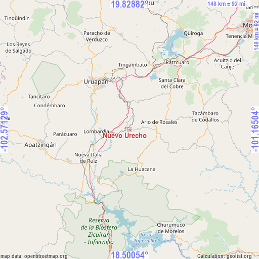
Nuevo Urecho GPS coordinates[2]
19° 9' 57.672" North, 101° 52' 5.376" West
| Map corner | latitude | longitude |
|---|---|---|
| Upper-left | 19.82882°, | -102.57129° |
| Center: | 19.16602°, | -101.86816° |
| Lower-right: | 18.50054°, | -101.16504° |
| Map W x H: | 147.7×147.7 km | = 91.8×91.8mi |
| max Lat: | 32.7° ⇑61.9% North |
| Nuevo Urecho: | 19.16602° |
| min Lat: | ⇓38.1% South 14.53588° |
| min Long | Nuevo Urecho | max Long |
| -117.105° | -101.86816° | -86.73105° |
| W 19.9%⇐ | ⇒80.1% E |
Elevation
Elevation of Nuevo Urecho is 765 m = 2510 ft, and this is 488.7 m = 1603 ft below average elevation for this country.
| Max E: |
3497 m = 11473 ft | 63.8% |
| Avg. | 1253.7 m = 4113 ft | |
| Nuevo Urecho | 765 m = 2510 ft | |
Min E: |
-1 m = -3 ft | 36.2% |
See also: Mexico elevation on elevation.city.
Geographical zone
Nuevo Urecho is located in North Torrid zone (between Equator and Tropic of Cancer). Distance of this Northern Tropic circle is 474.9 km =295.1 mi to North.| Distance of | km | miles | from Nuevo Urecho |
|---|---|---|---|
| North Pole | 7876 | 4893.9 | to North |
| Arctic Circle | 5270.1 | 3274.7 | to North |
| Tropic Cancer | 474.9 | 295.1 | to North |
| Equator | 2131.1 | 1324.2 | to South |


Nearby cities:
15 places around Nuevo Urecho: (largest is in red/bold)
• Ario de Rosales
17.5 km =10.9 mi,  74°
74°
• Doctor Miguel Silva Macías
14.8 km =9.2 mi,  90°
90°
• El Sabino
17.7 km =11 mi,  322°
322°
• La Florida
16.8 km =10.4 mi,  0°
0°
• La Ibérica (La Gotera)
5 km =3.1 mi,  268°
268°
• La Purísima
16 km =9.9 mi,  350°
350°
• Lombardía
19.2 km =11.9 mi, 267°
• Los Cajones
6.8 km =4.2 mi, 315°
• Los Otates
4.4 km =2.7 mi,  83°
83°
• Los Tumines
15.1 km =9.4 mi, 94°
• San José de Chuén
16.6 km =10.3 mi,  43°
43°
• San Vicente
12.5 km =7.8 mi,  10°
10°
• Santa Casilda
9.1 km =5.7 mi,  260°
260°
• Tomendán
16.2 km =10.1 mi, 2°
• Villa Eréndira
2.6 km =1.6 mi,  291°
291°
Sources, notices
• [Note1] Compared only with cities in Mexico existing in our database
• [Src1] Map data: © OpenStreetMap contributors (CC-BY-SA)
• [Src2] Other city data from geonames.org with taken over terms of usage.
• [Src3] Geographical zone / Annual Mean Temperature by Robert A. Rohde @ Wikipedia
