La Ibérica (La Gotera) geodata
La Ibérica (La Gotera) (Michoacán) is a populated place; located in Mexico in America/Mexico_City (GMT-6) time zone. With population of 1,308 people, there are 6634 cities with bigger population in this country. Compared to other cities in Mexico, 61.9% of cities are located further ↑North; 80.4% of cities are located further →East and 69.1% of cities have higher elevation than La Ibérica (La Gotera). Note1
Current local time in La Ibérica (La Gotera):
06:33 AM, WednesdayDifference from your time zone: hours


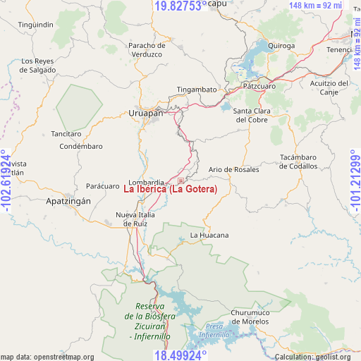
La Ibérica (La Gotera) GPS coordinates[2]
19° 9' 52.992" North, 101° 54' 57.996" West
| Map corner | latitude | longitude |
|---|---|---|
| Upper-left | 19.82753°, | -102.61924° |
| Center: | 19.16472°, | -101.91611° |
| Lower-right: | 18.49924°, | -101.21299° |
| Map W x H: | 147.7×147.7 km | = 91.8×91.8mi |
| max Lat: | 32.7° ⇑61.9% North |
| La Ibérica (La Gotera): | 19.16472° |
| min Lat: | ⇓38.1% South 14.53588° |
| min Long | La Ibérica (La | max Long |
| -117.105° | -101.91611° | -86.73105° |
| W 19.6%⇐ | ⇒80.4% E |
Elevation
Elevation of La Ibérica (La Gotera) is 463 m = 1519 ft, and this is 790.7 m = 2594 ft below average elevation for this country.
| Max E: |
3497 m = 11473 ft | 69.1% |
| Avg. | 1253.7 m = 4113 ft | |
| La Ibérica (La Gotera) | 463 m = 1519 ft | |
Min E: |
-1 m = -3 ft | 30.9% |
See also: Mexico elevation on elevation.city.
Geographical zone
La Ibérica (La Gotera) is located in North Torrid zone (between Equator and Tropic of Cancer). Distance of this Northern Tropic circle is 475 km =295.2 mi to North.| Distance of | km | miles | from La Ibérica (La Gotera) |
|---|---|---|---|
| North Pole | 7876.1 | 4894 | to North |
| Arctic Circle | 5270.3 | 3274.8 | to North |
| Tropic Cancer | 475 | 295.2 | to North |
| Equator | 2130.9 | 1324.1 | to South |


Nearby cities:
15 places around La Ibérica (La Gotera): (largest is in red/bold)
• Charapendo
19.2 km =11.9 mi,  304°
304°
• El Guaco
18.4 km =11.4 mi,  233°
233°
• El Sabino
15.3 km =9.5 mi,  337°
337°
• La Florida
17.7 km =11 mi,  17°
17°
• La Purísima
16.1 km =10 mi,  8°
8°
• Lombardía
14.2 km =8.8 mi,  267°
267°
• Los Cajones
5 km =3.1 mi,  3°
3°
• Los Otates
9.4 km =5.8 mi,  86°
86°
• Nuevo Urecho
5 km =3.1 mi, 88°
• San Vicente
14.4 km =8.9 mi,  30°
30°
• Santa Casilda
4.2 km =2.6 mi,  251°
251°
• Tahuejo
17.7 km =11 mi,  345°
345°
• Taretán
18.8 km =11.7 mi,  359°
359°
• Tomendán
17.3 km =10.7 mi, 19°
• Villa Eréndira
2.9 km =1.8 mi,  66°
66°
Sources, notices
• [Note1] Compared only with cities in Mexico existing in our database
• [Src1] Map data: © OpenStreetMap contributors (CC-BY-SA)
• [Src2] Other city data from geonames.org with taken over terms of usage.
• [Src3] Geographical zone / Annual Mean Temperature by Robert A. Rohde @ Wikipedia
