Nacozari Viejo geodata
Nacozari Viejo (Sonora) is a populated place; located in Mexico in America/Hermosillo (GMT-7) time zone. With population of 11,872 people, there are 810 cities with bigger population in this country. Compared to other cities in Mexico, 98.6% of cities are located further ↓South; 97.7% of cities are located further →East and 51.7% of cities have higher elevation than Nacozari Viejo. Note1


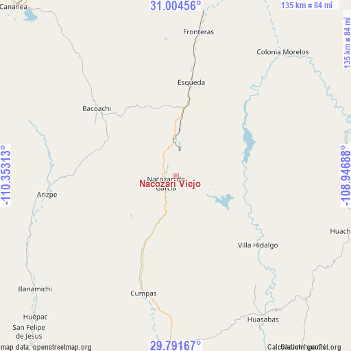
Nacozari Viejo GPS coordinates[2]
30° 24' 0" North, 109° 39' 0" West
| Map corner | latitude | longitude |
|---|---|---|
| Upper-left | 31.00456°, | -110.35313° |
| Center: | 30.4°, | -109.65° |
| Lower-right: | 29.79167°, | -108.94688° |
| Map W x H: | 134.9×134.9 km | = 83.8×83.8mi |
| max Lat: | 32.7° ⇑1.4% North |
| Nacozari Viejo: | 30.4° |
| min Lat: | ⇓98.6% South 14.53588° |
| min Long | Nacozari Viejo | max Long |
| -117.105° | -109.65° | -86.73105° |
| W 2.3%⇐ | ⇒97.7% E |
Elevation
Elevation of Nacozari Viejo is 1352 m = 4436 ft, and this is 98.3 m = 323 ft above average elevation for this country.
| Max E: |
3497 m = 11473 ft | 51.7% |
| Nacozari Viejo | 1352 m 4436 ft | |
| Avg. | 1253.7 m = 4113 ft | |
Min E: |
-1 m = -3 ft | 48.3% |
See also: Mexico elevation on elevation.city.
Geographical zone
Nacozari Viejo is located in North temperate zone (between Tropic of Cancer and the Arctic Circle). Distance of this Northern Tropic circle is 774.2 km =481.1 mi to South.| Distance of | km | miles | from Nacozari Viejo |
|---|---|---|---|
| North Pole | 6626.9 | 4117.8 | to North |
| Arctic Circle | 4021 | 2498.5 | to North |
| Tropic Cancer | 774.2 | 481.1 | to South |
| Equator | 3380.2 | 2100.4 | to South |


Nearby cities:
15 places around Nacozari Viejo: (largest is in red/bold)
• Arizpe
50 km =31.1 mi,  261°
261°
• Bacerac
69.1 km =42.9 mi,  94°
94°
• Bacoachi
39.9 km =24.8 mi,  310°
310°
• Bavispe
68.6 km =42.6 mi,  82°
82°
• Cumpas
46.7 km =29 mi,  195°
195°
• Esqueda
36.5 km =22.7 mi,  9°
9°
• Fronteras
56 km =34.8 mi, 8°
• Granados
68.2 km =42.4 mi,  151°
151°
• Huásabas
64.2 km =39.9 mi, 148°
• Jécori
52.2 km =32.4 mi,  189°
189°
• Los Hoyos
33.2 km =20.6 mi, 202°
• Moctezuma
66.1 km =41.1 mi,  182°
182°
• Nacozari de García
4.7 km =2.9 mi,  233°
233°
• Ojo de Agua
43 km =26.7 mi, 198°
• Villa Hidalgo
41.2 km =25.6 mi,  130°
130°
Sources, notices
• [Note1] Compared only with cities in Mexico existing in our database
• [Src1] Map data: © OpenStreetMap contributors (CC-BY-SA)
• [Src2] Other city data from geonames.org with taken over terms of usage.
• [Src3] Geographical zone / Annual Mean Temperature by Robert A. Rohde @ Wikipedia
