Esqueda geodata
Esqueda (Sonora) is a populated place; located in Mexico in America/Hermosillo (GMT-7) time zone. With population of 6,749 people, there are 1387 cities with bigger population in this country. Compared to other cities in Mexico, 98.8% of cities are located further ↓South; 97.6% of cities are located further →East and 54.8% of cities have higher elevation than Esqueda. Note1


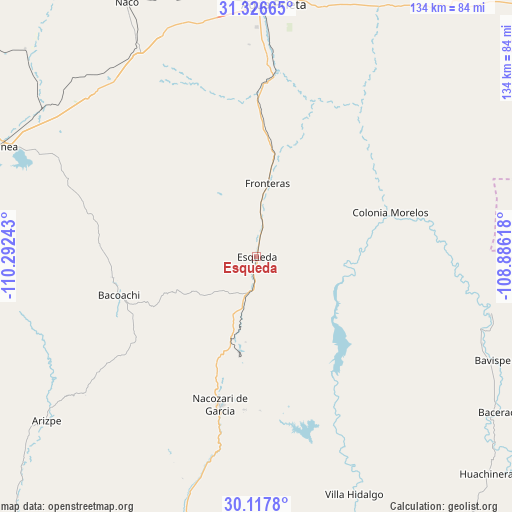
Esqueda GPS coordinates[2]
30° 43' 26.832" North, 109° 35' 21.48" West
| Map corner | latitude | longitude |
|---|---|---|
| Upper-left | 31.32665°, | -110.29243° |
| Center: | 30.72412°, | -109.5893° |
| Lower-right: | 30.1178°, | -108.88618° |
| Map W x H: | 134.4×134.4 km | = 83.5×83.5mi |
| max Lat: | 32.7° ⇑1.2% North |
| Esqueda: | 30.72412° |
| min Lat: | ⇓98.8% South 14.53588° |
| min Long | Esqueda | max Long |
| -117.105° | -109.5893° | -86.73105° |
| W 2.4%⇐ | ⇒97.6% E |
Elevation
Elevation of Esqueda is 1204 m = 3950 ft, and this is 49.7 m = 163 ft below average elevation for this country.
| Max E: |
3497 m = 11473 ft | 54.8% |
| Avg. | 1253.7 m = 4113 ft | |
| Esqueda | 1204 m = 3950 ft | |
Min E: |
-1 m = -3 ft | 45.2% |
See also: Mexico elevation on elevation.city.
Geographical zone
Esqueda is located in North temperate zone (between Tropic of Cancer and the Arctic Circle). Distance of this Northern Tropic circle is 810.3 km =503.5 mi to South.| Distance of | km | miles | from Esqueda |
|---|---|---|---|
| North Pole | 6590.9 | 4095.4 | to North |
| Arctic Circle | 3985 | 2476.2 | to North |
| Tropic Cancer | 810.3 | 503.5 | to South |
| Equator | 3416.2 | 2122.7 | to South |


Nearby cities:
15 places around Esqueda: (largest is in red/bold)
• Agua Prieta
67.6 km =42 mi,  3°
3°
• Arizpe
70.1 km =43.6 mi,  232°
232°
• Bacerac
75.1 km =46.7 mi,  123°
123°
• Bacoachi
37.7 km =23.4 mi,  254°
254°
• Bavispe
67.9 km =42.2 mi,  113°
113°
• Cananea
73 km =45.4 mi,  293°
293°
• Cumpas
83 km =51.6 mi,  192°
192°
• Fronteras
19.5 km =12.1 mi,  8°
8°
• Huachinera
83.2 km =51.7 mi,  133°
133°
• Los Hoyos
69.2 km =43 mi,  195°
195°
• Naco
75.2 km =46.7 mi,  333°
333°
• Nacozari Viejo
36.5 km =22.7 mi, 189°
• Nacozari de García
40 km =24.9 mi, 193°
• Ojo de Agua
79.2 km =49.2 mi, 193°
• Villa Hidalgo
67.6 km =42 mi,  157°
157°
Sources, notices
• [Note1] Compared only with cities in Mexico existing in our database
• [Src1] Map data: © OpenStreetMap contributors (CC-BY-SA)
• [Src2] Other city data from geonames.org with taken over terms of usage.
• [Src3] Geographical zone / Annual Mean Temperature by Robert A. Rohde @ Wikipedia
