Arizpe geodata
Arizpe (Sonora) is a seat of a second-order administrative division; located in Mexico in America/Hermosillo (GMT-7) time zone. With population of 1,718 people, there are 5050 cities with bigger population in this country. Compared to other cities in Mexico, 98.6% of cities are located further ↓South; 98.3% of cities are located further →East and 62.7% of cities have higher elevation than Arizpe. Note1


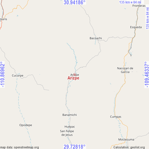
Arizpe GPS coordinates[2]
30° 20' 12.84" North, 110° 9' 59.364" West
| Map corner | latitude | longitude |
|---|---|---|
| Upper-left | 30.94186°, | -110.86962° |
| Center: | 30.3369°, | -110.16649° |
| Lower-right: | 29.72818°, | -109.46337° |
| Map W x H: | 134.9×134.9 km | = 83.8×83.8mi |
| max Lat: | 32.7° ⇑1.4% North |
| Arizpe: | 30.3369° |
| min Lat: | ⇓98.6% South 14.53588° |
| min Long | Arizpe | max Long |
| -117.105° | -110.16649° | -86.73105° |
| W 1.7%⇐ | ⇒98.3% E |
Elevation
Elevation of Arizpe is 837 m = 2746 ft, and this is 416.7 m = 1367 ft below average elevation for this country.
| Max E: |
3497 m = 11473 ft | 62.7% |
| Avg. | 1253.7 m = 4113 ft | |
| Arizpe | 837 m = 2746 ft | |
Min E: |
-1 m = -3 ft | 37.3% |
See also: Mexico elevation on elevation.city.
Geographical zone
Arizpe is located in North temperate zone (between Tropic of Cancer and the Arctic Circle). Distance of this Northern Tropic circle is 767.2 km =476.7 mi to South.| Distance of | km | miles | from Arizpe |
|---|---|---|---|
| North Pole | 6633.9 | 4122.1 | to North |
| Arctic Circle | 4028 | 2502.9 | to North |
| Tropic Cancer | 767.2 | 476.7 | to South |
| Equator | 3373.1 | 2095.9 | to South |


Nearby cities:
15 places around Arizpe: (largest is in red/bold)
• Aconchi
57.1 km =35.5 mi,  185°
185°
• Bacoachi
37.9 km =23.5 mi,  30°
30°
• Banámichi
36.9 km =22.9 mi, 187°
• Baviácora
69.3 km =43.1 mi,  179°
179°
• Cucurpe
51.8 km =32.2 mi,  269°
269°
• Cumpas
53 km =32.9 mi,  135°
135°
• Huépac
47.5 km =29.5 mi, 185°
• Jécori
60.8 km =37.8 mi, 137°
• La Estancia
60.5 km =37.6 mi, 183°
• Los Hoyos
43.8 km =27.2 mi,  122°
122°
• Nacozari Viejo
50 km =31.1 mi,  81°
81°
• Nacozari de García
46 km =28.6 mi, 84°
• Ojo de Agua
49.6 km =30.8 mi,  132°
132°
• Opodepe
63.8 km =39.6 mi,  224°
224°
• San Felipe de Jesús
53.3 km =33.1 mi, 187°
Sources, notices
• [Note1] Compared only with cities in Mexico existing in our database
• [Src1] Map data: © OpenStreetMap contributors (CC-BY-SA)
• [Src2] Other city data from geonames.org with taken over terms of usage.
• [Src3] Geographical zone / Annual Mean Temperature by Robert A. Rohde @ Wikipedia
