Fronteras geodata
Fronteras (Sonora) is a seat of a second-order administrative division; located in Mexico in America/Hermosillo (GMT-7) time zone. With population of 834 people, there are 10487 cities with bigger population in this country. Compared to other cities in Mexico, 98.9% of cities are located further ↓South; 97.6% of cities are located further →East and 56.6% of cities have higher elevation than Fronteras. Note1


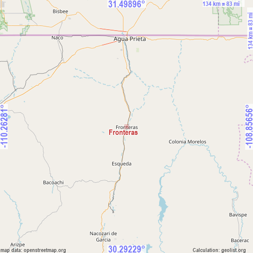
Fronteras GPS coordinates[2]
30° 53' 51.108" North, 109° 33' 34.848" West
| Map corner | latitude | longitude |
|---|---|---|
| Upper-left | 31.49896°, | -110.26281° |
| Center: | 30.89753°, | -109.55968° |
| Lower-right: | 30.29229°, | -108.85656° |
| Map W x H: | 134.2×134.2 km | = 83.4×83.4mi |
| max Lat: | 32.7° ⇑1.1% North |
| Fronteras: | 30.89753° |
| min Lat: | ⇓98.9% South 14.53588° |
| min Long | Fronteras | max Long |
| -117.105° | -109.55968° | -86.73105° |
| W 2.4%⇐ | ⇒97.6% E |
Elevation
Elevation of Fronteras is 1135 m = 3724 ft, and this is 118.7 m = 389 ft below average elevation for this country.
| Max E: |
3497 m = 11473 ft | 56.6% |
| Avg. | 1253.7 m = 4113 ft | |
| Fronteras | 1135 m = 3724 ft | |
Min E: |
-1 m = -3 ft | 43.4% |
See also: Mexico elevation on elevation.city.
Geographical zone
Fronteras is located in North temperate zone (between Tropic of Cancer and the Arctic Circle). Distance of this Northern Tropic circle is 829.6 km =515.5 mi to South.| Distance of | km | miles | from Fronteras |
|---|---|---|---|
| North Pole | 6571.6 | 4083.4 | to North |
| Arctic Circle | 3965.7 | 2464.2 | to North |
| Tropic Cancer | 829.6 | 515.5 | to South |
| Equator | 3435.5 | 2134.7 | to South |


Nearby cities:
15 places around Fronteras: (largest is in red/bold)
• Agua Prieta
48.2 km =30 mi,  1°
1°
• Arizpe
85.2 km =52.9 mi,  222°
222°
• Bacerac
85.1 km =52.9 mi,  135°
135°
• Bacoachi
49 km =30.4 mi,  232°
232°
• Bavispe
75.3 km =46.8 mi,  128°
128°
• Cananea
70.4 km =43.7 mi,  278°
278°
• Esqueda
19.5 km =12.1 mi,  188°
188°
• Huachinera
95.7 km =59.5 mi, 143°
• Los Hoyos
88.6 km =55.1 mi, 193°
• Monte Verde
80.5 km =50 mi,  88°
88°
• Naco
60.3 km =37.5 mi,  322°
322°
• Nacozari Viejo
56 km =34.8 mi, 188°
• Nacozari de García
59.4 km =36.9 mi, 192°
• Pancho Villa
87.9 km =54.6 mi,  96°
96°
• Villa Hidalgo
84.9 km =52.8 mi,  164°
164°
Sources, notices
• [Note1] Compared only with cities in Mexico existing in our database
• [Src1] Map data: © OpenStreetMap contributors (CC-BY-SA)
• [Src2] Other city data from geonames.org with taken over terms of usage.
• [Src3] Geographical zone / Annual Mean Temperature by Robert A. Rohde @ Wikipedia
