Bavispe geodata
Bavispe (Sonora) is a seat of a second-order administrative division; located in Mexico in America/Hermosillo (GMT-7) time zone. With population of 701 people, there are 12418 cities with bigger population in this country. Compared to other cities in Mexico, 98.6% of cities are located further ↓South; 96.9% of cities are located further →East and 59.8% of cities have higher elevation than Bavispe. Note1


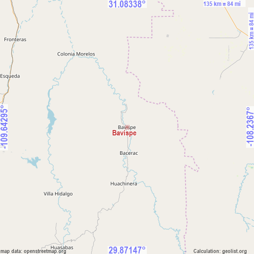
Bavispe GPS coordinates[2]
30° 28' 45.516" North, 108° 56' 23.352" West
| Map corner | latitude | longitude |
|---|---|---|
| Upper-left | 31.08338°, | -109.64295° |
| Center: | 30.47931°, | -108.93982° |
| Lower-right: | 29.87147°, | -108.2367° |
| Map W x H: | 134.8×134.8 km | = 83.8×83.8mi |
| max Lat: | 32.7° ⇑1.4% North |
| Bavispe: | 30.47931° |
| min Lat: | ⇓98.6% South 14.53588° |
| min Long | Bavispe | max Long |
| -117.105° | -108.93982° | -86.73105° |
| W 3.1%⇐ | ⇒96.9% E |
Elevation
Elevation of Bavispe is 1016 m = 3333 ft, and this is 237.7 m = 780 ft below average elevation for this country.
| Max E: |
3497 m = 11473 ft | 59.8% |
| Avg. | 1253.7 m = 4113 ft | |
| Bavispe | 1016 m = 3333 ft | |
Min E: |
-1 m = -3 ft | 40.2% |
See also: Mexico elevation on elevation.city.
Geographical zone
Bavispe is located in North temperate zone (between Tropic of Cancer and the Arctic Circle). Distance of this Northern Tropic circle is 783.1 km =486.6 mi to South.| Distance of | km | miles | from Bavispe |
|---|---|---|---|
| North Pole | 6618.1 | 4112.3 | to North |
| Arctic Circle | 4012.2 | 2493.1 | to North |
| Tropic Cancer | 783.1 | 486.6 | to South |
| Equator | 3389 | 2105.8 | to South |


Nearby cities:
15 places around Bavispe: (largest is in red/bold)
• Bacadéhuachi
77 km =47.8 mi,  194°
194°
• Bacerac
13.8 km =8.6 mi,  176°
176°
• Esqueda
67.9 km =42.2 mi,  293°
293°
• Fernández Leal
75 km =46.6 mi,  56°
56°
• Fronteras
75.3 km =46.8 mi,  308°
308°
• Granados
77.3 km =48 mi,  207°
207°
• Huachinera
30 km =18.6 mi, 183°
• Huásabas
72.4 km =45 mi, 208°
• Mesa Tres Ríos
74.3 km =46.2 mi,  162°
162°
• Monte Verde
52.9 km =32.9 mi,  23°
23°
• Nacozari Viejo
68.6 km =42.6 mi,  262°
262°
• Nacozari de García
72.8 km =45.2 mi, 260°
• Pancho Villa
45.6 km =28.3 mi,  38°
38°
• Tres Álamos
72.3 km =44.9 mi, 58°
• Villa Hidalgo
50.9 km =31.6 mi,  226°
226°
Sources, notices
• [Note1] Compared only with cities in Mexico existing in our database
• [Src1] Map data: © OpenStreetMap contributors (CC-BY-SA)
• [Src2] Other city data from geonames.org with taken over terms of usage.
• [Src3] Geographical zone / Annual Mean Temperature by Robert A. Rohde @ Wikipedia
