Mazatán geodata
Mazatán (Nayarit) is a populated place; located in Mexico in America/Mazatlan (GMT-7) time zone. With population of 956 people, there are 9116 cities with bigger population in this country. Compared to other cities in Mexico, 78.5% of cities are located further ↓South; 91.8% of cities are located further →East and 65.2% of cities have higher elevation than Mazatán. Note1


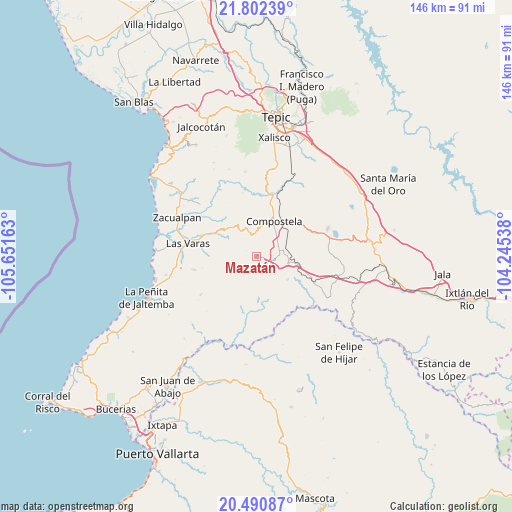
Mazatán GPS coordinates[2]
21° 8' 53.088" North, 104° 56' 54.6" West
| Map corner | latitude | longitude |
|---|---|---|
| Upper-left | 21.80239°, | -105.65163° |
| Center: | 21.14808°, | -104.9485° |
| Lower-right: | 20.49087°, | -104.24538° |
| Map W x H: | 145.8×145.8 km | = 90.6×90.6mi |
| max Lat: | 32.7° ⇑21.5% North |
| Mazatán: | 21.14808° |
| min Lat: | ⇓78.5% South 14.53588° |
| min Long | Mazatán | max Long |
| -117.105° | -104.9485° | -86.73105° |
| W 8.2%⇐ | ⇒91.8% E |
Elevation
Elevation of Mazatán is 674 m = 2211 ft, and this is 579.7 m = 1902 ft below average elevation for this country.
| Max E: |
3497 m = 11473 ft | 65.2% |
| Avg. | 1253.7 m = 4113 ft | |
| Mazatán | 674 m = 2211 ft | |
Min E: |
-1 m = -3 ft | 34.8% |
See also: Mexico elevation on elevation.city.
Geographical zone
Mazatán is located in North Torrid zone (between Equator and Tropic of Cancer). Distance of this Northern Tropic circle is 254.5 km =158.1 mi to North.| Distance of | km | miles | from Mazatán |
|---|---|---|---|
| North Pole | 7655.6 | 4757 | to North |
| Arctic Circle | 5049.7 | 3137.7 | to North |
| Tropic Cancer | 254.5 | 158.1 | to North |
| Equator | 2351.4 | 1461.1 | to South |


Nearby cities:
15 places around Mazatán: (largest is in red/bold)
• Cofradía de Chocolón
24.2 km =15 mi,  352°
352°
• Compostela
11.2 km =7 mi,  26°
26°
• Cuastecomate
23.4 km =14.5 mi,  119°
119°
• El Capomo
18.3 km =11.4 mi,  257°
257°
• El Paranal (Arocha)
19.7 km =12.2 mi,  315°
315°
• Emiliano Zapata
24.4 km =15.2 mi,  8°
8°
• Felipe Carrillo Puerto
9.3 km =5.8 mi,  101°
101°
• Juan Escutia (Borbollón)
8.7 km =5.4 mi,  75°
75°
• La Puerta de la Lima
24.9 km =15.5 mi, 256°
• Las Piedras
16.2 km =10.1 mi,  291°
291°
• Las Varas
19.8 km =12.3 mi,  280°
280°
• Miravalles
16.9 km =10.5 mi, 25°
• San Pedro Lagunillas
21.8 km =13.5 mi,  68°
68°
• Tequilita
17 km =10.6 mi,  113°
113°
• Zapotán
11.1 km =6.9 mi,  126°
126°
Sources, notices
• [Note1] Compared only with cities in Mexico existing in our database
• [Src1] Map data: © OpenStreetMap contributors (CC-BY-SA)
• [Src2] Other city data from geonames.org with taken over terms of usage.
• [Src3] Geographical zone / Annual Mean Temperature by Robert A. Rohde @ Wikipedia
