Compostela geodata
Compostela (Nayarit) is a seat of a second-order administrative division; located in Mexico in America/Mazatlan (GMT-7) time zone. With population of 17,573 people, there are 551 cities with bigger population in this country. Compared to other cities in Mexico, 79.5% of cities are located further ↓South; 91.8% of cities are located further →East and 62.5% of cities have higher elevation than Compostela. Note1


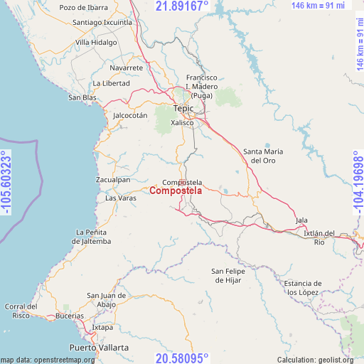
Compostela GPS coordinates[2]
21° 14' 15.972" North, 104° 54' 0.36" West
| Map corner | latitude | longitude |
|---|---|---|
| Upper-left | 21.89167°, | -105.60323° |
| Center: | 21.23777°, | -104.9001° |
| Lower-right: | 20.58095°, | -104.19698° |
| Map W x H: | 145.7×145.7 km | = 90.5×90.5mi |
| max Lat: | 32.7° ⇑20.5% North |
| Compostela: | 21.23777° |
| min Lat: | ⇓79.5% South 14.53588° |
| min Long | Compostela | max Long |
| -117.105° | -104.9001° | -86.73105° |
| W 8.2%⇐ | ⇒91.8% E |
Elevation
Elevation of Compostela is 855 m = 2805 ft, and this is 398.7 m = 1308 ft below average elevation for this country.
| Max E: |
3497 m = 11473 ft | 62.5% |
| Avg. | 1253.7 m = 4113 ft | |
| Compostela | 855 m = 2805 ft | |
Min E: |
-1 m = -3 ft | 37.5% |
See also: Mexico elevation on elevation.city.
Geographical zone
Compostela is located in North Torrid zone (between Equator and Tropic of Cancer). Distance of this Northern Tropic circle is 244.5 km =151.9 mi to North.| Distance of | km | miles | from Compostela |
|---|---|---|---|
| North Pole | 7645.6 | 4750.8 | to North |
| Arctic Circle | 5039.8 | 3131.6 | to North |
| Tropic Cancer | 244.5 | 151.9 | to North |
| Equator | 2361.4 | 1467.3 | to South |


Nearby cities:
15 places around Compostela: (largest is in red/bold)
• Aquiles Serdán
16.1 km =10 mi,  4°
4°
• Cofradía de Chocolón
16.3 km =10.1 mi,  329°
329°
• El Malinal
19.6 km =12.2 mi,  318°
318°
• El Paranal (Arocha)
19.2 km =11.9 mi,  282°
282°
• Emiliano Zapata
14.2 km =8.8 mi,  354°
354°
• Felipe Carrillo Puerto
12.5 km =7.8 mi,  160°
160°
• Juan Escutia (Borbollón)
8.5 km =5.3 mi, 156°
• La Curva
15 km =9.3 mi,  25°
25°
• Las Piedras
20.5 km =12.7 mi,  258°
258°
• Mazatán
11.2 km =7 mi,  206°
206°
• Miravalles
5.7 km =3.5 mi,  23°
23°
• San Pedro Lagunillas
15.5 km =9.6 mi,  97°
97°
• Tequilita
19.8 km =12.3 mi,  147°
147°
• Testerazo
18.3 km =11.4 mi, 1°
• Zapotán
17 km =10.6 mi,  166°
166°
Sources, notices
• [Note1] Compared only with cities in Mexico existing in our database
• [Src1] Map data: © OpenStreetMap contributors (CC-BY-SA)
• [Src2] Other city data from geonames.org with taken over terms of usage.
• [Src3] Geographical zone / Annual Mean Temperature by Robert A. Rohde @ Wikipedia
