Los Espinos geodata
Los Espinos (Jalisco) is a populated place; located in Mexico in America/Mexico_City (GMT-6) time zone. With population of 682 people, there are 12741 cities with bigger population in this country. Compared to other cities in Mexico, 56.7% of cities are located further ↓South; 89.2% of cities are located further →East and 85.7% of cities have lower elevation than Los Espinos. Note1


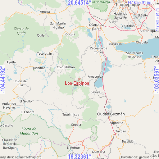
Los Espinos GPS coordinates[2]
19° 59' 8.736" North, 103° 44' 19.644" West
| Map corner | latitude | longitude |
|---|---|---|
| Upper-left | 20.64514°, | -104.44192° |
| Center: | 19.98576°, | -103.73879° |
| Lower-right: | 19.32361°, | -103.03567° |
| Map W x H: | 146.9×146.9 km | = 91.3×91.3mi |
| max Lat: | 32.7° ⇑43.3% North |
| Los Espinos: | 19.98576° |
| min Lat: | ⇓56.7% South 14.53588° |
| min Long | Los Espinos | max Long |
| -117.105° | -103.73879° | -86.73105° |
| W 10.8%⇐ | ⇒89.2% E |
Elevation
Elevation of Los Espinos is 2274 m = 7461 ft, and this is 1020.3 m = 3347 ft above average elevation for this country.
| Max E: |
3497 m = 11473 ft | 14.3% |
| Los Espinos | 2274 m 7461 ft | |
| Avg. | 1253.7 m = 4113 ft | |
Min E: |
-1 m = -3 ft | 85.7% |
See also: Mexico elevation on elevation.city.
Geographical zone
Los Espinos is located in North Torrid zone (between Equator and Tropic of Cancer). Distance of this Northern Tropic circle is 383.7 km =238.4 mi to North.| Distance of | km | miles | from Los Espinos |
|---|---|---|---|
| North Pole | 7784.9 | 4837.3 | to North |
| Arctic Circle | 5179 | 3218.1 | to North |
| Tropic Cancer | 383.7 | 238.4 | to North |
| Equator | 2222.2 | 1380.8 | to South |


Nearby cities:
15 places around Los Espinos: (largest is in red/bold)
• Amacueca
14.8 km =9.2 mi,  79°
79°
• Apango
23 km =14.3 mi,  172°
172°
• Atacco
6.6 km =4.1 mi,  183°
183°
• Atemajac de Brizuela
16.9 km =10.5 mi,  4°
4°
• Atoyac
23.4 km =14.5 mi, 83°
• Chiquilistlán
17.1 km =10.6 mi,  311°
311°
• Cuyacapan
22.6 km =14 mi,  95°
95°
• Ferrería de Tula
8.9 km =5.5 mi,  6°
6°
• Juanacatlán
7.6 km =4.7 mi,  46°
46°
• Los Colonos
6 km =3.7 mi,  217°
217°
• San Antonio
3.8 km =2.4 mi,  123°
123°
• Sayula
18.5 km =11.5 mi,  128°
128°
• Tapalpa
5 km =3.1 mi,  205°
205°
• Techaluta de Montenegro
21.9 km =13.6 mi,  63°
63°
• Tepec
10.2 km =6.3 mi,  87°
87°
Sources, notices
• [Note1] Compared only with cities in Mexico existing in our database
• [Src1] Map data: © OpenStreetMap contributors (CC-BY-SA)
• [Src2] Other city data from geonames.org with taken over terms of usage.
• [Src3] Geographical zone / Annual Mean Temperature by Robert A. Rohde @ Wikipedia
