Tepec geodata
Tepec (Jalisco) is a populated place; located in Mexico in America/Mexico_City (GMT-6) time zone. With population of 1,900 people, there are 4578 cities with bigger population in this country. Compared to other cities in Mexico, 56.8% of cities are located further ↓South; 88.8% of cities are located further →East and 55.4% of cities have lower elevation than Tepec. Note1


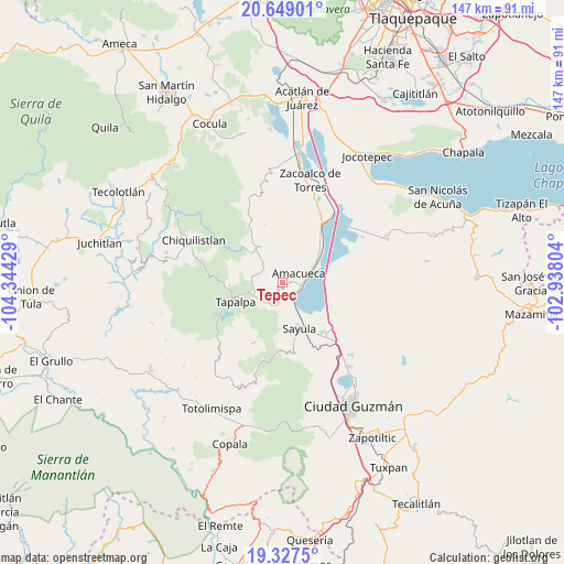
Tepec GPS coordinates[2]
19° 59' 22.704" North, 103° 38' 28.176" West
| Map corner | latitude | longitude |
|---|---|---|
| Upper-left | 20.64901°, | -104.34429° |
| Center: | 19.98964°, | -103.64116° |
| Lower-right: | 19.3275°, | -102.93804° |
| Map W x H: | 146.9×146.9 km | = 91.3×91.3mi |
| max Lat: | 32.7° ⇑43.2% North |
| Tepec: | 19.98964° |
| min Lat: | ⇓56.8% South 14.53588° |
| min Long | Tepec | max Long |
| -117.105° | -103.64116° | -86.73105° |
| W 11.2%⇐ | ⇒88.8% E |
Elevation
Elevation of Tepec is 1600 m = 5249 ft, and this is 346.3 m = 1136 ft above average elevation for this country.
| Max E: |
3497 m = 11473 ft | 44.6% |
| Tepec | 1600 m 5249 ft | |
| Avg. | 1253.7 m = 4113 ft | |
Min E: |
-1 m = -3 ft | 55.4% |
See also: Mexico elevation on elevation.city.
Geographical zone
Tepec is located in North Torrid zone (between Equator and Tropic of Cancer). Distance of this Northern Tropic circle is 383.3 km =238.2 mi to North.| Distance of | km | miles | from Tepec |
|---|---|---|---|
| North Pole | 7784.4 | 4837 | to North |
| Arctic Circle | 5178.5 | 3217.8 | to North |
| Tropic Cancer | 383.3 | 238.2 | to North |
| Equator | 2222.6 | 1381.1 | to South |


Nearby cities:
15 places around Tepec: (largest is in red/bold)
• Amacueca
4.9 km =3 mi,  61°
61°
• Atacco
12.7 km =7.9 mi,  236°
236°
• Atemajac de Brizuela
18.7 km =11.6 mi,  331°
331°
• Atoyac
13.2 km =8.2 mi,  80°
80°
• Cuyacapan
12.5 km =7.8 mi,  101°
101°
• Ferrería de Tula
12.5 km =7.8 mi,  312°
312°
• Juanacatlán
6.7 km =4.2 mi,  315°
315°
• Los Colonos
14.8 km =9.2 mi,  249°
249°
• Los Espinos
10.2 km =6.3 mi,  267°
267°
• San Antonio
7.5 km =4.7 mi, 250°
• Sayula
12.7 km =7.9 mi,  160°
160°
• Tapalpa
13.3 km =8.3 mi, 248°
• Techaluta de Montenegro
13.2 km =8.2 mi,  45°
45°
• Unión de Guadalupe
21.8 km =13.5 mi,  114°
114°
• Usmajac
16.5 km =10.3 mi,  140°
140°
Sources, notices
• [Note1] Compared only with cities in Mexico existing in our database
• [Src1] Map data: © OpenStreetMap contributors (CC-BY-SA)
• [Src2] Other city data from geonames.org with taken over terms of usage.
• [Src3] Geographical zone / Annual Mean Temperature by Robert A. Rohde @ Wikipedia
