San Antonio geodata
San Antonio (Jalisco) is a populated place; located in Mexico in America/Mexico_City (GMT-6) time zone. With population of 717 people, there are 12151 cities with bigger population in this country. Compared to other cities in Mexico, 56.3% of cities are located further ↓South; 89.1% of cities are located further →East and 86.1% of cities have lower elevation than San Antonio. Note1


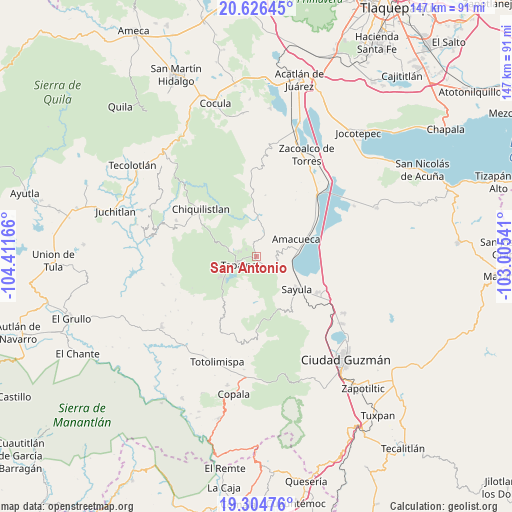
San Antonio GPS coordinates[2]
19° 58' 1.164" North, 103° 42' 30.708" West
| Map corner | latitude | longitude |
|---|---|---|
| Upper-left | 20.62645°, | -104.41166° |
| Center: | 19.96699°, | -103.70853° |
| Lower-right: | 19.30476°, | -103.00541° |
| Map W x H: | 147×147 km | = 91.3×91.3mi |
| max Lat: | 32.7° ⇑43.7% North |
| San Antonio: | 19.96699° |
| min Lat: | ⇓56.3% South 14.53588° |
| min Long | San Antonio | max Long |
| -117.105° | -103.70853° | -86.73105° |
| W 10.9%⇐ | ⇒89.1% E |
Elevation
Elevation of San Antonio is 2285 m = 7497 ft, and this is 1031.3 m = 3384 ft above average elevation for this country.
| Max E: |
3497 m = 11473 ft | 13.9% |
| San Antonio | 2285 m 7497 ft | |
| Avg. | 1253.7 m = 4113 ft | |
Min E: |
-1 m = -3 ft | 86.1% |
See also: Mexico elevation on elevation.city.
Geographical zone
San Antonio is located in North Torrid zone (between Equator and Tropic of Cancer). Distance of this Northern Tropic circle is 385.8 km =239.7 mi to North.| Distance of | km | miles | from San Antonio |
|---|---|---|---|
| North Pole | 7786.9 | 4838.6 | to North |
| Arctic Circle | 5181.1 | 3219.4 | to North |
| Tropic Cancer | 385.8 | 239.7 | to North |
| Equator | 2220.1 | 1379.5 | to South |


Nearby cities:
15 places around San Antonio: (largest is in red/bold)
• Amacueca
12.4 km =7.7 mi,  66°
66°
• Apango
20.7 km =12.9 mi,  180°
180°
• Atacco
5.7 km =3.5 mi,  218°
218°
• Atemajac de Brizuela
19 km =11.8 mi,  354°
354°
• Atoyac
20.6 km =12.8 mi,  76°
76°
• Cuyacapan
19.3 km =12 mi,  89°
89°
• Ferrería de Tula
11.2 km =7 mi, 348°
• Juanacatlán
7.7 km =4.8 mi,  17°
17°
• Los Colonos
7.3 km =4.5 mi,  248°
248°
• Los Espinos
3.8 km =2.4 mi,  303°
303°
• Sayula
14.7 km =9.1 mi,  129°
129°
• Tapalpa
5.8 km =3.6 mi, 245°
• Techaluta de Montenegro
20.2 km =12.6 mi,  54°
54°
• Tepec
7.5 km =4.7 mi, 70°
• Usmajac
20.3 km =12.6 mi,  120°
120°
Sources, notices
• [Note1] Compared only with cities in Mexico existing in our database
• [Src1] Map data: © OpenStreetMap contributors (CC-BY-SA)
• [Src2] Other city data from geonames.org with taken over terms of usage.
• [Src3] Geographical zone / Annual Mean Temperature by Robert A. Rohde @ Wikipedia
