Baroten geodata
Baroten (Sinaloa) is a populated place; located in Mexico in America/Mazatlan (GMT-7) time zone. With population of 846 people, there are 10344 cities with bigger population in this country. Compared to other cities in Mexico, 95.7% of cities are located further ↓South; 96.5% of cities are located further →East and 81.4% of cities have higher elevation than Baroten. Note1


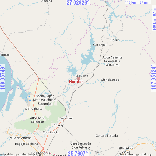
Baroten GPS coordinates[2]
26° 24' 4.32" North, 108° 39' 15.696" West
| Map corner | latitude | longitude |
|---|---|---|
| Upper-left | 27.02926°, | -109.35749° |
| Center: | 26.4012°, | -108.65436° |
| Lower-right: | 25.7697°, | -107.95124° |
| Map W x H: | 140×140.1 km | = 87×87.1mi |
| max Lat: | 32.7° ⇑4.3% North |
| Baroten: | 26.4012° |
| min Lat: | ⇓95.7% South 14.53588° |
| min Long | Baroten | max Long |
| -117.105° | -108.65436° | -86.73105° |
| W 3.5%⇐ | ⇒96.5% E |
Elevation
Elevation of Baroten is 77 m = 253 ft, and this is 1176.7 m = 3861 ft below average elevation for this country.
| Max E: |
3497 m = 11473 ft | 81.4% |
| Avg. | 1253.7 m = 4113 ft | |
| Baroten | 77 m = 253 ft | |
Min E: |
-1 m = -3 ft | 18.6% |
See also: Mexico elevation on elevation.city.
Geographical zone
Baroten is located in North temperate zone (between Tropic of Cancer and the Arctic Circle). Distance of this Northern Tropic circle is 329.6 km =204.8 mi to South.| Distance of | km | miles | from Baroten |
|---|---|---|---|
| North Pole | 7071.5 | 4394 | to North |
| Arctic Circle | 4465.6 | 2774.8 | to North |
| Tropic Cancer | 329.6 | 204.8 | to South |
| Equator | 2935.5 | 1824 | to South |


Nearby cities:
15 places around Baroten: (largest is in red/bold)
• Boca de Arroyo
13.6 km =8.5 mi,  226°
226°
• Chinobampo
28.9 km =18 mi,  92°
92°
• El Canutillo
4.2 km =2.6 mi,  136°
136°
• El Fuerte
4 km =2.5 mi,  64°
64°
• Estación Hoyancos (Estación el Fuerte)
7.1 km =4.4 mi,  121°
121°
• La Bajada del Monte
8.5 km =5.3 mi,  212°
212°
• Las Estacas
18.7 km =11.6 mi,  215°
215°
• Los Capomos
14 km =8.7 mi,  79°
79°
• Lázaro Cárdenas
29.2 km =18.1 mi,  247°
247°
• Mulanjey
26.9 km =16.7 mi,  196°
196°
• Mulanjey (Estación Vega)
26.9 km =16.7 mi, 196°
• Palo Verde
29.2 km =18.1 mi, 250°
• San Pedro
22.6 km =14 mi,  53°
53°
• Sibajahui
29.2 km =18.1 mi, 196°
• Tehueco
14.8 km =9.2 mi, 217°
Sources, notices
• [Note1] Compared only with cities in Mexico existing in our database
• [Src1] Map data: © OpenStreetMap contributors (CC-BY-SA)
• [Src2] Other city data from geonames.org with taken over terms of usage.
• [Src3] Geographical zone / Annual Mean Temperature by Robert A. Rohde @ Wikipedia
