Emiliano Zapata geodata
Emiliano Zapata (San Luis Potosí) is a populated place; located in Mexico in America/Mexico_City (GMT-6) time zone. With population of 1,460 people, there are 5918 cities with bigger population in this country. Compared to other cities in Mexico, 83.6% of cities are located further ↓South; 72.7% of cities are located further →East and 65.2% of cities have lower elevation than Emiliano Zapata. Note1


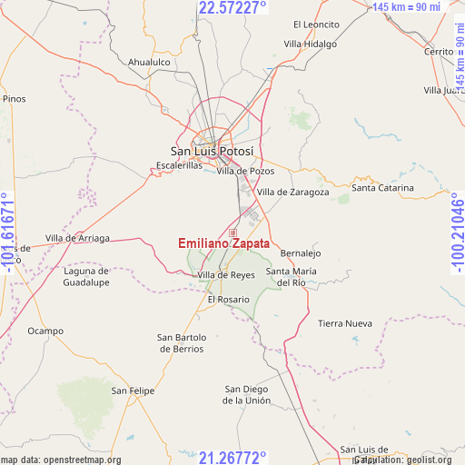
Emiliano Zapata GPS coordinates[2]
21° 55' 17.364" North, 100° 54' 48.888" West
| Map corner | latitude | longitude |
|---|---|---|
| Upper-left | 22.57227°, | -101.61671° |
| Center: | 21.92149°, | -100.91358° |
| Lower-right: | 21.26772°, | -100.21046° |
| Map W x H: | 145.1×145.1 km | = 90.2×90.2mi |
| max Lat: | 32.7° ⇑16.4% North |
| Emiliano Zapata: | 21.92149° |
| min Lat: | ⇓83.6% South 14.53588° |
| min Long | Emiliano Zapata | max Long |
| -117.105° | -100.91358° | -86.73105° |
| W 27.3%⇐ | ⇒72.7% E |
Elevation
Elevation of Emiliano Zapata is 1834 m = 6017 ft, and this is 580.3 m = 1904 ft above average elevation for this country.
| Max E: |
3497 m = 11473 ft | 34.8% |
| Emiliano Zapata | 1834 m 6017 ft | |
| Avg. | 1253.7 m = 4113 ft | |
Min E: |
-1 m = -3 ft | 65.2% |
See also: Mexico elevation on elevation.city.
Geographical zone
Emiliano Zapata is located in North Torrid zone (between Equator and Tropic of Cancer). Distance of this Northern Tropic circle is 168.5 km =104.7 mi to North.| Distance of | km | miles | from Emiliano Zapata |
|---|---|---|---|
| North Pole | 7569.6 | 4703.5 | to North |
| Arctic Circle | 4963.7 | 3084.3 | to North |
| Tropic Cancer | 168.5 | 104.7 | to North |
| Equator | 2437.4 | 1514.5 | to South |


Nearby cities:
15 places around Emiliano Zapata: (largest is in red/bold)
• Cerro Gordo
12.5 km =7.8 mi,  61°
61°
• Ejido Gogorrón (Ex-Hacienda de Gogorrón)
9 km =5.6 mi,  178°
178°
• Ejido el Saucillo
12.6 km =7.8 mi,  221°
221°
• El Mirador
6.8 km =4.2 mi,  115°
115°
• El Terrero Sur
13.2 km =8.2 mi,  2°
2°
• Enramadas
14.2 km =8.8 mi,  107°
107°
• La Pila
13.4 km =8.3 mi,  20°
20°
• La Presa (La Presita)
1.3 km =0.8 mi,  302°
302°
• Laguna de San Vicente
6.2 km =3.9 mi, 64°
• Machado
5.8 km =3.6 mi,  203°
203°
• Pardo
7.3 km =4.5 mi,  125°
125°
• Rodrigo
5.3 km =3.3 mi,  231°
231°
• San Lorenzo
5 km =3.1 mi, 110°
• Socavón (El Carmen)
8.9 km =5.5 mi,  151°
151°
• Villa de Reyes
13.3 km =8.3 mi,  189°
189°
Sources, notices
• [Note1] Compared only with cities in Mexico existing in our database
• [Src1] Map data: © OpenStreetMap contributors (CC-BY-SA)
• [Src2] Other city data from geonames.org with taken over terms of usage.
• [Src3] Geographical zone / Annual Mean Temperature by Robert A. Rohde @ Wikipedia
