Acuítzio del Canje geodata
Acuítzio del Canje (Michoacán) is a seat of a second-order administrative division; located in Mexico in America/Mexico_City (GMT-6) time zone. With population of 6,733 people, there are 1393 cities with bigger population in this country. Compared to other cities in Mexico, 54.1% of cities are located further ↑North; 75.9% of cities are located further →East and 77.8% of cities have lower elevation than Acuítzio del Canje. Note1


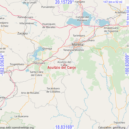
Acuítzio del Canje GPS coordinates[2]
19° 29' 45.06" North, 101° 19' 59.556" West
| Map corner | latitude | longitude |
|---|---|---|
| Upper-left | 20.15729°, | -102.03634° |
| Center: | 19.49585°, | -101.33321° |
| Lower-right: | 18.83169°, | -100.63009° |
| Map W x H: | 147.4×147.4 km | = 91.6×91.6mi |
| max Lat: | 32.7° ⇑54.1% North |
| Acuítzio del Canje: | 19.49585° |
| min Lat: | ⇓45.9% South 14.53588° |
| min Long | Acuítzio del C | max Long |
| -117.105° | -101.33321° | -86.73105° |
| W 24.1%⇐ | ⇒75.9% E |
Elevation
Elevation of Acuítzio del Canje is 2085 m = 6841 ft, and this is 831.3 m = 2727 ft above average elevation for this country.
| Max E: |
3497 m = 11473 ft | 22.2% |
| Acuítzio del Canje | 2085 m 6841 ft | |
| Avg. | 1253.7 m = 4113 ft | |
Min E: |
-1 m = -3 ft | 77.8% |
See also: Mexico elevation on elevation.city.
Geographical zone
Acuítzio del Canje is located in North Torrid zone (between Equator and Tropic of Cancer). Distance of this Northern Tropic circle is 438.2 km =272.3 mi to North.| Distance of | km | miles | from Acuítzio del Canje |
|---|---|---|---|
| North Pole | 7839.3 | 4871.1 | to North |
| Arctic Circle | 5233.4 | 3251.9 | to North |
| Tropic Cancer | 438.2 | 272.3 | to North |
| Equator | 2167.7 | 1346.9 | to South |


Nearby cities:
15 places around Acuítzio del Canje: (largest is in red/bold)
• Chihuerio
6.6 km =4.1 mi,  258°
258°
• Cutzaro
5.4 km =3.4 mi,  181°
181°
• El Pedregal
12.3 km =7.6 mi,  277°
277°
• Estación Jácuaro (Colonia la Reunión)
11.9 km =7.4 mi,  21°
21°
• Huiramba
12.2 km =7.6 mi,  297°
297°
• La Estancia
10.6 km =6.6 mi,  14°
14°
• Lagunillas
11.4 km =7.1 mi,  310°
310°
• Las Tablas
11.3 km =7 mi,  272°
272°
• San Andrés Coapa
5.2 km =3.2 mi, 273°
• San José Coapa
8.8 km =5.5 mi,  321°
321°
• San Rafael Coapa
4.6 km =2.9 mi, 317°
• Santiago Undameo
12.2 km =7.6 mi, 24°
• Tirio
9.3 km =5.8 mi,  38°
38°
• Tirípetio
6.1 km =3.8 mi,  346°
346°
• Villa Madero
12.9 km =8 mi,  153°
153°
Sources, notices
• [Note1] Compared only with cities in Mexico existing in our database
• [Src1] Map data: © OpenStreetMap contributors (CC-BY-SA)
• [Src2] Other city data from geonames.org with taken over terms of usage.
• [Src3] Geographical zone / Annual Mean Temperature by Robert A. Rohde @ Wikipedia
