Las Tablas geodata
Las Tablas (Michoacán) is a populated place; located in Mexico in America/Mexico_City (GMT-6) time zone. With population of 582 people, there are 14734 cities with bigger population in this country. Compared to other cities in Mexico, 54% of cities are located further ↑North; 76.9% of cities are located further →East and 87.1% of cities have lower elevation than Las Tablas. Note1


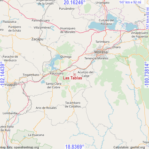
Las Tablas GPS coordinates[2]
19° 30' 3.744" North, 101° 26' 28.536" West
| Map corner | latitude | longitude |
|---|---|---|
| Upper-left | 20.16246°, | -102.14439° |
| Center: | 19.50104°, | -101.44126° |
| Lower-right: | 18.8369°, | -100.73814° |
| Map W x H: | 147.4×147.4 km | = 91.6×91.6mi |
| max Lat: | 32.7° ⇑54% North |
| Las Tablas: | 19.50104° |
| min Lat: | ⇓46% South 14.53588° |
| min Long | Las Tablas | max Long |
| -117.105° | -101.44126° | -86.73105° |
| W 23.1%⇐ | ⇒76.9% E |
Elevation
Elevation of Las Tablas is 2312 m = 7585 ft, and this is 1058.3 m = 3472 ft above average elevation for this country.
| Max E: |
3497 m = 11473 ft | 12.9% |
| Las Tablas | 2312 m 7585 ft | |
| Avg. | 1253.7 m = 4113 ft | |
Min E: |
-1 m = -3 ft | 87.1% |
See also: Mexico elevation on elevation.city.
Geographical zone
Las Tablas is located in North Torrid zone (between Equator and Tropic of Cancer). Distance of this Northern Tropic circle is 437.6 km =271.9 mi to North.| Distance of | km | miles | from Las Tablas |
|---|---|---|---|
| North Pole | 7838.7 | 4870.7 | to North |
| Arctic Circle | 5232.9 | 3251.6 | to North |
| Tropic Cancer | 437.6 | 271.9 | to North |
| Equator | 2168.3 | 1347.3 | to South |


Nearby cities:
15 places around Las Tablas: (largest is in red/bold)
• Canacucho
5.8 km =3.6 mi,  245°
245°
• Chihuerio
5.2 km =3.2 mi,  111°
111°
• Cuanajo
7.2 km =4.5 mi,  255°
255°
• El Pedregal
1.4 km =0.9 mi,  322°
322°
• El Refugio
6.2 km =3.9 mi,  236°
236°
• El Sobrado
2.7 km =1.7 mi,  303°
303°
• Fontezuelas
9.3 km =5.8 mi,  352°
352°
• Huiramba
5 km =3.1 mi,  5°
5°
• La Caja
9.6 km =6 mi,  4°
4°
• Lagunillas
7.4 km =4.6 mi,  21°
21°
• San Andrés Coapa
6.1 km =3.8 mi,  92°
92°
• San José Coapa
8.6 km =5.3 mi,  42°
42°
• San Rafael Coapa
8.7 km =5.4 mi,  71°
71°
• Tirípetio
11.3 km =7 mi,  61°
61°
• Tupátaro
5.3 km =3.3 mi,  271°
271°
Sources, notices
• [Note1] Compared only with cities in Mexico existing in our database
• [Src1] Map data: © OpenStreetMap contributors (CC-BY-SA)
• [Src2] Other city data from geonames.org with taken over terms of usage.
• [Src3] Geographical zone / Annual Mean Temperature by Robert A. Rohde @ Wikipedia
