Tirípetio geodata
Tirípetio (Michoacán) is a populated place; located in Mexico in America/Mexico_City (GMT-6) time zone. With population of 2,050 people, there are 4252 cities with bigger population in this country. Compared to other cities in Mexico, 53.1% of cities are located further ↑North; 76% of cities are located further →East and 74.2% of cities have lower elevation than Tirípetio. Note1


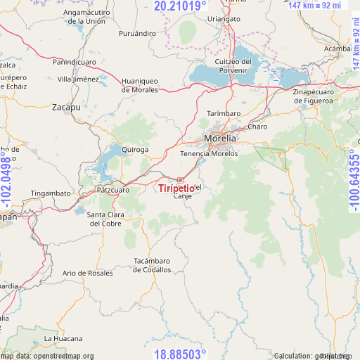
Tirípetio GPS coordinates[2]
19° 32' 56.292" North, 101° 20' 48.012" West
| Map corner | latitude | longitude |
|---|---|---|
| Upper-left | 20.21019°, | -102.0498° |
| Center: | 19.54897°, | -101.34667° |
| Lower-right: | 18.88503°, | -100.64355° |
| Map W x H: | 147.3×147.3 km | = 91.5×91.5mi |
| max Lat: | 32.7° ⇑53.1% North |
| Tirípetio: | 19.54897° |
| min Lat: | ⇓46.9% South 14.53588° |
| min Long | Tirípetio | max Long |
| -117.105° | -101.34667° | -86.73105° |
| W 24%⇐ | ⇒76% E |
Elevation
Elevation of Tirípetio is 2016 m = 6614 ft, and this is 762.3 m = 2501 ft above average elevation for this country.
| Max E: |
3497 m = 11473 ft | 25.8% |
| Tirípetio | 2016 m 6614 ft | |
| Avg. | 1253.7 m = 4113 ft | |
Min E: |
-1 m = -3 ft | 74.2% |
See also: Mexico elevation on elevation.city.
Geographical zone
Tirípetio is located in North Torrid zone (between Equator and Tropic of Cancer). Distance of this Northern Tropic circle is 432.3 km =268.6 mi to North.| Distance of | km | miles | from Tirípetio |
|---|---|---|---|
| North Pole | 7833.4 | 4867.4 | to North |
| Arctic Circle | 5227.5 | 3248.2 | to North |
| Tropic Cancer | 432.3 | 268.6 | to North |
| Equator | 2173.6 | 1350.6 | to South |


Nearby cities:
15 places around Tirípetio: (largest is in red/bold)
• Acuítzio del Canje
6.1 km =3.8 mi,  166°
166°
• Chihuerio
8.8 km =5.5 mi,  214°
214°
• Cutzaro
11.3 km =7 mi, 173°
• Estación Jácuaro (Colonia la Reunión)
7.8 km =4.8 mi,  48°
48°
• Huiramba
9.4 km =5.8 mi,  268°
268°
• La Caja
10 km =6.2 mi,  294°
294°
• La Estancia
6 km =3.7 mi,  43°
43°
• Lagunillas
7.4 km =4.6 mi,  281°
281°
• Las Tablas
11.3 km =7 mi,  241°
241°
• San Andrés Coapa
6.8 km =4.2 mi, 213°
• San José Coapa
4.2 km =2.6 mi, 283°
• San Rafael Coapa
3 km =1.9 mi, 213°
• Santiago Undameo
8.3 km =5.2 mi, 51°
• Tirio
7.4 km =4.6 mi,  78°
78°
• Uruapilla
10.6 km =6.6 mi, 42°
Sources, notices
• [Note1] Compared only with cities in Mexico existing in our database
• [Src1] Map data: © OpenStreetMap contributors (CC-BY-SA)
• [Src2] Other city data from geonames.org with taken over terms of usage.
• [Src3] Geographical zone / Annual Mean Temperature by Robert A. Rohde @ Wikipedia
