Punta de la Vega geodata
Punta de la Vega (Jalisco) is a populated place; located in Mexico in America/Mexico_City (GMT-6) time zone. With population of 1,077 people, there are 8093 cities with bigger population in this country. Compared to other cities in Mexico, 69.8% of cities are located further ↓South; 89.7% of cities are located further →East and 53.3% of cities have higher elevation than Punta de la Vega. Note1


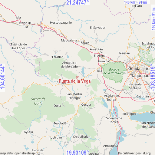
Punta de la Vega GPS coordinates[2]
20° 35' 26.52" North, 103° 53' 53.916" West
| Map corner | latitude | longitude |
|---|---|---|
| Upper-left | 21.24747°, | -104.60144° |
| Center: | 20.5907°, | -103.89831° |
| Lower-right: | 19.93109°, | -103.19519° |
| Map W x H: | 146.4×146.4 km | = 91×91mi |
| max Lat: | 32.7° ⇑30.2% North |
| Punta de la Vega: | 20.5907° |
| min Lat: | ⇓69.8% South 14.53588° |
| min Long | Punta de la Veg | max Long |
| -117.105° | -103.89831° | -86.73105° |
| W 10.3%⇐ | ⇒89.7% E |
Elevation
Elevation of Punta de la Vega is 1275 m = 4183 ft, and this is 21.3 m = 70 ft above average elevation for this country.
| Max E: |
3497 m = 11473 ft | 53.3% |
| Punta de la Vega | 1275 m 4183 ft | |
| Avg. | 1253.7 m = 4113 ft | |
Min E: |
-1 m = -3 ft | 46.7% |
See also: Mexico elevation on elevation.city.
Geographical zone
Punta de la Vega is located in North Torrid zone (between Equator and Tropic of Cancer). Distance of this Northern Tropic circle is 316.4 km =196.6 mi to North.| Distance of | km | miles | from Punta de la Vega |
|---|---|---|---|
| North Pole | 7717.6 | 4795.5 | to North |
| Arctic Circle | 5111.7 | 3176.3 | to North |
| Tropic Cancer | 316.4 | 196.6 | to North |
| Equator | 2289.5 | 1422.6 | to South |


Nearby cities:
15 places around Punta de la Vega: (largest is in red/bold)
• Buenavista
5.4 km =3.4 mi,  117°
117°
• Castro Urdiales
8.1 km =5 mi,  84°
84°
• Cuisillos
13.1 km =8.1 mi, 80°
• El Amarillo
4.5 km =2.8 mi,  5°
5°
• El Cabezón
11.9 km =7.4 mi,  207°
207°
• El Carmen
7.2 km =4.5 mi,  348°
348°
• El Ranchito (San Isidro)
12 km =7.5 mi, 84°
• El Salitre
9.9 km =6.2 mi,  154°
154°
• La Estanzuela
11.5 km =7.1 mi,  40°
40°
• La Vega
4.2 km =2.6 mi,  101°
101°
• Labor de Solís
9.5 km =5.9 mi,  254°
254°
• Los Pocitos
7.2 km =4.5 mi, 214°
• Portes Gil
8.6 km =5.3 mi,  330°
330°
• Teuchitlán
11.6 km =7.2 mi,  26°
26°
• Trapiche de Abra
10 km =6.2 mi, 124°
Sources, notices
• [Note1] Compared only with cities in Mexico existing in our database
• [Src1] Map data: © OpenStreetMap contributors (CC-BY-SA)
• [Src2] Other city data from geonames.org with taken over terms of usage.
• [Src3] Geographical zone / Annual Mean Temperature by Robert A. Rohde @ Wikipedia
