La Yerba geodata
La Yerba (Nayarit) is a populated place; located in Mexico in America/Mazatlan (GMT-7) time zone. With population of 786 people, there are 11112 cities with bigger population in this country. Compared to other cities in Mexico, 81.5% of cities are located further ↓South; 92% of cities are located further →East and 62.1% of cities have higher elevation than La Yerba. Note1


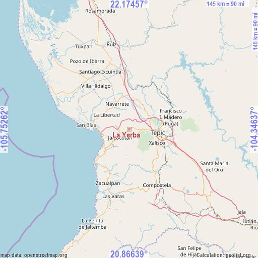
La Yerba GPS coordinates[2]
21° 31' 19.02" North, 105° 2' 58.164" West
| Map corner | latitude | longitude |
|---|---|---|
| Upper-left | 22.17457°, | -105.75262° |
| Center: | 21.52195°, | -105.04949° |
| Lower-right: | 20.86639°, | -104.34637° |
| Map W x H: | 145.5×145.5 km | = 90.4×90.4mi |
| max Lat: | 32.7° ⇑18.5% North |
| La Yerba: | 21.52195° |
| min Lat: | ⇓81.5% South 14.53588° |
| min Long | La Yerba | max Long |
| -117.105° | -105.04949° | -86.73105° |
| W 8%⇐ | ⇒92% E |
Elevation
Elevation of La Yerba is 878 m = 2881 ft, and this is 375.7 m = 1233 ft below average elevation for this country.
| Max E: |
3497 m = 11473 ft | 62.1% |
| Avg. | 1253.7 m = 4113 ft | |
| La Yerba | 878 m = 2881 ft | |
Min E: |
-1 m = -3 ft | 37.9% |
See also: Mexico elevation on elevation.city.
Geographical zone
La Yerba is located in North Torrid zone (between Equator and Tropic of Cancer). Distance of this Northern Tropic circle is 212.9 km =132.3 mi to North.| Distance of | km | miles | from La Yerba |
|---|---|---|---|
| North Pole | 7614 | 4731.1 | to North |
| Arctic Circle | 5008.2 | 3112 | to North |
| Tropic Cancer | 212.9 | 132.3 | to North |
| Equator | 2393 | 1486.9 | to South |


Nearby cities:
15 places around La Yerba: (largest is in red/bold)
• Aticama
15.9 km =9.9 mi,  254°
254°
• Cuarenteño
7.4 km =4.6 mi,  164°
164°
• El Ahuacate
10.9 km =6.8 mi,  93°
93°
• El Malinal
17.1 km =10.6 mi,  171°
171°
• El Rincón
12.9 km =8 mi,  68°
68°
• El Trapichillo
8.9 km =5.5 mi,  50°
50°
• Jalcocotán
6.8 km =4.2 mi,  228°
228°
• La Bajada
11.4 km =7.1 mi,  259°
259°
• La Fortuna
10.8 km =6.7 mi, 71°
• La Libertad
15.1 km =9.4 mi,  301°
301°
• La Palma
13.7 km =8.5 mi, 255°
• Lo de Lamedo
11.5 km =7.1 mi,  80°
80°
• Mecatán
7.4 km =4.6 mi,  282°
282°
• Navarrete
15.6 km =9.7 mi,  334°
334°
• Tepic
16 km =9.9 mi, 94°
Sources, notices
• [Note1] Compared only with cities in Mexico existing in our database
• [Src1] Map data: © OpenStreetMap contributors (CC-BY-SA)
• [Src2] Other city data from geonames.org with taken over terms of usage.
• [Src3] Geographical zone / Annual Mean Temperature by Robert A. Rohde @ Wikipedia
