Cuarenteño geodata
Cuarenteño (Nayarit) is a populated place; located in Mexico in America/Mazatlan (GMT-7) time zone. With population of 683 people, there are 12712 cities with bigger population in this country. Compared to other cities in Mexico, 81.2% of cities are located further ↓South; 91.9% of cities are located further →East and 59.7% of cities have higher elevation than Cuarenteño. Note1


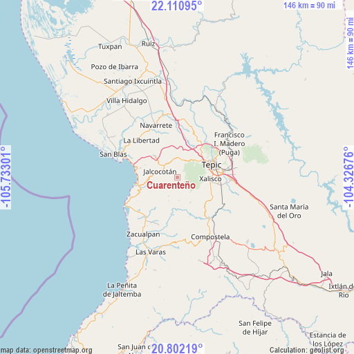
Cuarenteño GPS coordinates[2]
21° 27' 28.944" North, 105° 1' 47.568" West
| Map corner | latitude | longitude |
|---|---|---|
| Upper-left | 22.11095°, | -105.73301° |
| Center: | 21.45804°, | -105.02988° |
| Lower-right: | 20.80219°, | -104.32676° |
| Map W x H: | 145.5×145.5 km | = 90.4×90.4mi |
| max Lat: | 32.7° ⇑18.8% North |
| Cuarenteño: | 21.45804° |
| min Lat: | ⇓81.2% South 14.53588° |
| min Long | Cuarenteño | max Long |
| -117.105° | -105.02988° | -86.73105° |
| W 8.1%⇐ | ⇒91.9% E |
Elevation
Elevation of Cuarenteño is 1019 m = 3343 ft, and this is 234.7 m = 770 ft below average elevation for this country.
| Max E: |
3497 m = 11473 ft | 59.7% |
| Avg. | 1253.7 m = 4113 ft | |
| Cuarenteño | 1019 m = 3343 ft | |
Min E: |
-1 m = -3 ft | 40.3% |
See also: Mexico elevation on elevation.city.
Geographical zone
Cuarenteño is located in North Torrid zone (between Equator and Tropic of Cancer). Distance of this Northern Tropic circle is 220 km =136.7 mi to North.| Distance of | km | miles | from Cuarenteño |
|---|---|---|---|
| North Pole | 7621.2 | 4735.6 | to North |
| Arctic Circle | 5015.3 | 3116.4 | to North |
| Tropic Cancer | 220 | 136.7 | to North |
| Equator | 2385.9 | 1482.5 | to South |


Nearby cities:
15 places around Cuarenteño: (largest is in red/bold)
• Cofradía de Chocolón
11.7 km =7.3 mi,  153°
153°
• El Ahuacate
10.9 km =6.8 mi,  54°
54°
• El Malinal
9.8 km =6.1 mi,  176°
176°
• El Rincón
15.4 km =9.6 mi,  40°
40°
• El Trapichillo
13.6 km =8.5 mi,  20°
20°
• Jalcocotán
7.6 km =4.7 mi,  289°
289°
• La Bajada
14.2 km =8.8 mi, 290°
• La Fortuna
13.3 km =8.3 mi, 37°
• La Palma
15.8 km =9.8 mi,  283°
283°
• La Yerba
7.4 km =4.6 mi,  344°
344°
• Lo de Lamedo
12.9 km =8 mi, 46°
• Mecatán
12.7 km =7.9 mi,  313°
313°
• Tepic
15 km =9.3 mi,  67°
67°
• Testerazo
15.3 km =9.5 mi,  113°
113°
• Xalisco
13.6 km =8.5 mi,  93°
93°
Sources, notices
• [Note1] Compared only with cities in Mexico existing in our database
• [Src1] Map data: © OpenStreetMap contributors (CC-BY-SA)
• [Src2] Other city data from geonames.org with taken over terms of usage.
• [Src3] Geographical zone / Annual Mean Temperature by Robert A. Rohde @ Wikipedia
