El Rodeo geodata
El Rodeo (Jalisco) is a populated place; located in Mexico in America/Mexico_City (GMT-6) time zone. With population of 908 people, there are 9617 cities with bigger population in this country. Compared to other cities in Mexico, 53.8% of cities are located further ↓South; 88% of cities are located further →East and 73.9% of cities have lower elevation than El Rodeo. Note1


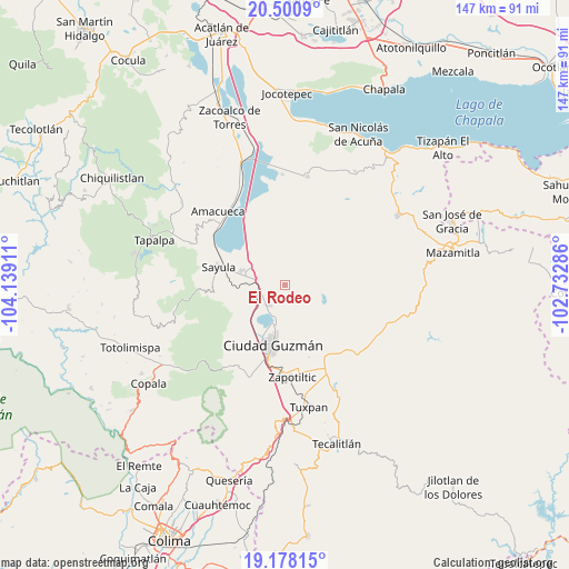
El Rodeo GPS coordinates[2]
19° 50' 27.24" North, 103° 26' 9.528" West
| Map corner | latitude | longitude |
|---|---|---|
| Upper-left | 20.5009°, | -104.13911° |
| Center: | 19.8409°, | -103.43598° |
| Lower-right: | 19.17815°, | -102.73286° |
| Map W x H: | 147.1×147.1 km | = 91.4×91.4mi |
| max Lat: | 32.7° ⇑46.2% North |
| El Rodeo: | 19.8409° |
| min Lat: | ⇓53.8% South 14.53588° |
| min Long | El Rodeo | max Long |
| -117.105° | -103.43598° | -86.73105° |
| W 12%⇐ | ⇒88% E |
Elevation
Elevation of El Rodeo is 2009 m = 6591 ft, and this is 755.3 m = 2478 ft above average elevation for this country.
| Max E: |
3497 m = 11473 ft | 26.1% |
| El Rodeo | 2009 m 6591 ft | |
| Avg. | 1253.7 m = 4113 ft | |
Min E: |
-1 m = -3 ft | 73.9% |
See also: Mexico elevation on elevation.city.
Geographical zone
El Rodeo is located in North Torrid zone (between Equator and Tropic of Cancer). Distance of this Northern Tropic circle is 399.8 km =248.4 mi to North.| Distance of | km | miles | from El Rodeo |
|---|---|---|---|
| North Pole | 7801 | 4847.3 | to North |
| Arctic Circle | 5195.1 | 3228.1 | to North |
| Tropic Cancer | 399.8 | 248.4 | to North |
| Equator | 2206.1 | 1370.8 | to South |


Nearby cities:
15 places around El Rodeo: (largest is in red/bold)
• Atoyac
20.6 km =12.8 mi,  335°
335°
• Ciudad Guzmán
15.4 km =9.6 mi,  190°
190°
• Ciudad Guzmán [CERESO]
22.1 km =13.7 mi,  197°
197°
• Concepción de Buenos Aires
23.9 km =14.9 mi,  50°
50°
• Cuyacapan
16.8 km =10.4 mi,  326°
326°
• El Rincón
19.6 km =12.2 mi,  169°
169°
• Gómez Farías
6.8 km =4.2 mi,  218°
218°
• San Andrés Ixtlán
4.2 km =2.6 mi,  235°
235°
• San Sebastián del Sur
6.5 km =4 mi, 216°
• Sayula
17.8 km =11.1 mi,  284°
284°
• Soyatlán de Afuera
23.1 km =14.4 mi,  136°
136°
• Unión de Guadalupe
7.8 km =4.8 mi,  348°
348°
• Usmajac
11.6 km =7.2 mi,  288°
288°
• Vista Hermosa
19.2 km =11.9 mi,  148°
148°
• Zapotiltic
23.8 km =14.8 mi,  175°
175°
Sources, notices
• [Note1] Compared only with cities in Mexico existing in our database
• [Src1] Map data: © OpenStreetMap contributors (CC-BY-SA)
• [Src2] Other city data from geonames.org with taken over terms of usage.
• [Src3] Geographical zone / Annual Mean Temperature by Robert A. Rohde @ Wikipedia
